Watershed Modeling
This page connects you to descriptions of computer models designed to address particular watershed functions or processes. It includes models for hydrology, ecology, water quality, overall watershed condition, and other topic areas. You can scroll down through the list, or "Quick Link" to a category of models in the pull-down list below. The model title is highlighted in the left-hand column, and its corresponding short description is to the right. Just click on th model title to go to the description, which is a "pdf" file. |
| Climate |
| CALVIN |
CALVIN is an economic-engineering optimization model for the entire water system of California. The model operates facilities and allocates water so as to maximize statewide agricultural and urban economic value from water use. |
| PRMS |
PRMS is a distributed-parameter modeling system used for evaluating the impacts of precipitation, climate and landuse on stream flow, sedimentation and general hydrology. |
| Decision Support |
| ANNIE |
ANNIE is a Data Analysis Package that assists users with watershed modeling projects, regional regression analysis projects, and time-series data management efforts. |
| ARSP |
ARSP is designed to determine optimal water allocation within a time series for virtually any water resource system. |
| BRANCH |
BRANCH is a physical model used to simulate flow in single or network of channels. |
| CALVIN |
CALVIN is an economic-engineering optimization model for the entire water system of California. The model operates facilities and allocates water so as to maximize statewide agricultural and urban economic value from water use. |
| CORMIX |
CORMIX allows users to assess the mixing zones associated with continuous point-source discharges. |
| CWHR |
CWHR is a model of potential wildlife habitat in California that aids in resource conservation, planning, and predictive modeling |
| ECOFATE |
ECOFATE is a computer tool used for assessing chemical emissions from point and non-point source pollution sources for the purpose of developing Ecosystem-based risk assessments and determining potential effect on human health. |
| EMDS |
EMDS is an application framework for knowledge-based decision support of ecological assessments at any geographic scale. The system integrates GIS and knowledge-based reasoning and decision modeling technologies to provide decision support for a substantial portion of the adaptive management process of ecosystem management. |
| EMSOFT |
EMSOFT is a computer application that determines concentrations of contaminants in the soil over time, quantifies the transfer rate of the contaminants into the atmosphere and calculates the contaminant air concentrations. |
| EXAMS |
EXAMS is a computer modeling program that evaluates the fate, transport and exposure of pesticides, industrial materials and other leaching materials from disposal sites. |
| GEOWEPP |
GeoWEPP is a continuous simulation model that allows for simulation of soil and water conservation management in terms of agricultural land, range land and forested sites in small watersheds. |
| LISEM |
LISEM is a soil erosion model used to simulate the hydrology and sediment transport during and after rainfall events. The model is most ideally used as a research tool. |
| MODBRNCH |
MODBRNCH is a finite-difference ground-water flow model that can be used to simulate steady and unsteady flows in irregularly shaped channel systems. |
| MOSES |
MOSES provides managers a tool to predict the outcomes of different management strategies associated with erosion control practices and associated remediation efforts. |
| NetWeaver |
NetWeaver is a knowledge base construction, maintenance, documentation, and debugging tool to provide an efficient knowledge engineering environment for knowledge based systems development. |
| PACFISH |
PACFISH monitoring modules were created to track implementation of USFS and BLM management plans for the salmon, steelhead, and bull trout listed in the Upper Columbia and Snake River Basins. Data is stored in the form of surveys using an Access Database. |
| PHABSIM |
PHABSIM is a tool that offers prediction capabilities associated with flow changes such as microhabitat, physical habitat and life stage changes. |
| RAMAS-GIS4.0 |
RAMAS GIS links GIS to an ecological model for use in population viability analysis with landscape-based data that incorporate changes in habitat into a meta-population and combine geographic and demographic data for risk assessments. |
| RAMAS MULTISPECIES |
RAMAS Multispecies links GIS to an ecological model allowing the user to incorporate landscape data in population viability analyses, incorporate changes in habitat into a meta-population model, combine geographic and demographic data for risk assessments, and compute the Multispecies Conservation Values (MCV) across a study site. |
| RAMAS REDLIST |
RAMAS Red List allows for users to characterize species a risk assessment category based on input information. |
| RAMAS RISK CALC3.0 |
RAMAS Risk Calc is used to compute values based on precise or uncertain numbers. |
| R STATISTICAL PACKAGE |
The R Statistical Package can be used for statistical analysis, simulation modeling and advanced data analysis. |
| SITES |
SITES is a physical model used to create conservation portfolios that represent examples of all native species and plant communities. |
| UPLAN |
UPLAN is an urban growth model that tests the effects of land use and transportation policies on growth. |
| WEPP |
The Water Erosion Prediction Project (WEPP) model is used to predict erosion on hillslopes and small watersheds. |
| Ecological |
| CWHR |
CWHR is a model of potential wildlife habitat in California that aids in resource conservation, planning, and predictive modeling |
| PACFISH |
PACFISH monitoring modules were created to track implementation of USFS and BLM management plans for the salmon, steelhead, and bull trout listed in the Upper Columbia and Snake River Basins. Data is stored in the form of surveys using an Access Database. |
| RAMAS-ECOTOX |
RAMAS Ecotoxicology is a data analysis package used for modeling population-level ecological risk assessments. |
| Geomorphology |
| BRANCH |
BRANCH is a physical model used to simulate flow in single or network of channels. |
| CGAP |
CGAP allows for the analysis, interpretation and quantification of properties associated with open channels. |
| ECOFATE |
ECOFATE is a computer tool used for assessing chemical emissions from point and non-point source pollution sources for the purpose of developing Ecosystem-based risk assessments and determining potential effect on human health. |
| FOURPT |
FOURPT simulates unsteady one-dimensional flow in open channel networks and can be used for simulation complex and meandering networks and hydraulic structures. |
| GEOWEPP |
GeoWEPP is a continuous simulation model that allows for simulation of soil and water conservation management in terms of agricultural land, range land and forested sites in small watersheds. |
| HSCTM2D |
HSCTM2D is a two-dimensional hydrodynamic model that is used to simulate surface water flow, sediment and contaminant transport. |
| LISEM |
LISEM is a soil erosion model used to simulate the hydrology and sediment transport during and after rainfall events. The model is most ideally used as a research tool. |
| MODBRNCH |
MODBRNCH is a finite-difference ground-water flow model that can be used to simulate steady and unsteady flows in irregularly shaped channel systems. |
| MOSES |
MOSES provides managers a tool to predict the outcomes of different management strategies associated with erosion control practices and associated remediation efforts. |
| RIVERMORPH |
RiverMorph is designed to streamline time consuming tasks performed by river restoration professionals. |
| RUSLE2 |
RUSLE is a physical model that can be used for assessing run-off and erosion. |
| SEDSIZE |
SEDDISCH is used to compute fluvial discharge based on user preferences. |
| SHALSTAB |
SHALSTAB is a physical model used for mapping the patter of shallow slope instabilities. |
| WEPP |
The Water Erosion Prediction Project (WEPP) model is used to predict erosion on hillslopes and small watersheds. |
| WMS |
The Watershed Modeling System (WMS) is a modeling system for watershed hydrology and hydraulics. WMS is capable of automated delineation of sub-watershed boundaries and flood extent, and includes graphic display options to aid in understanding the drainage characteristics of terrain surfaces as well as several computation features. |
| Habitat Classification |
| CWHR |
CWHR is a model of potential wildlife habitat in California that aids in resource conservation, planning, and predictive modeling |
| FUZZY CASIMIR |
The Fuzzy Fish Model applies fuzzy-logic methodology to flow regimes, bed flow statistics and hydraulic and morphologic criteria in order to more efficiently model fish habitat. |
| PACFISH |
PACFISH monitoring modules were created to track implementation of USFS and BLM management plans for the salmon, steelhead, and bull trout listed in the Upper Columbia and Snake River Basins. Data is stored in the form of surveys using an Access Database. |
| PATCH |
PATCH is a physical model that provides population viability modeling for territorial terrestrial vertebrate species. |
| RAMAS REDLIST |
RAMAS Red List allows for users to characterize species a risk assessment category based on input information. |
| SALMOD |
SALMOD is used to simulate the dynamics of freshwater, anadromous and resident salmonid populations. |
| Hydrology & Water Use |
| AIRSLUG |
AIRSLUG is a conceptual model used for assessing the capabilities of aquifers for storing and transmitting water by presenting the resulting values in plotted curves. |
| ANALGWST |
ANALGWST can be used to predict 1, 2, and 3-dimensional solute transport in groundwater based on the findings of E.J. Wexler. |
| ANNIE |
ANNIE is a Data Analysis Package that assists users with watershed modeling projects, regional regression analysis projects, and time-series data management efforts. |
| ANSWERS-2000 |
Answers-2000 is a physical model that can be used for the continuous-simulation of agricultural and urban ‘Best-Management-Practices’ in terms of sediment and nutrient delivery to surface runoff, and the associated leaching of nitrogen through the root zone. |
| AQTESTSS |
The AQTESTSS model allows users to analyze aquifer tests and associated ‘slug’ data through a series of spreadsheets. |
| ARSP |
ARSP is designed to determine optimal water allocation within a time series for virtually any water resource system. |
| BASINS |
BASINS is a physical model used for the evaluation of point and non-point source watershed pollution and TMDL modeling. |
| BRANCH |
BRANCH is a physical model used to simulate flow in single or network of channels. |
| CALVIN |
CALVIN is an economic-engineering optimization model for the entire water system of California. The model operates facilities and allocates water so as to maximize statewide agricultural and urban economic value from water use. |
| CHECK-RAS |
CHECK-RAS is a data analysis package that allows users to evaluate the outputs from HEC-RAS to determine their reasonableness. |
| DADFLOW |
DADFLOW is used for modeling and assessing stream flow based on Lagrangian methods while predicting discharge and transport velocity. |
| DR3M |
DR3M is a watershed model that can be used to assess the routing of storm-water-runoff through a system / network of pipes or natural channels and is usually used to simulate small urban basins |
| FEMWATER |
FEMWATER can be used to apply assimilative capacity criterion to development of wellhead protection areas and model the movement of moisture and solute transport through variably saturated porous media as required under the 1986 Safe Drinking Water Act Amendments. |
| FESWMS-2DH |
FESWMS-2DH simulates two-dimensional surface water flow for uses such as analyzing complicated hydraulic conditions, such as bridge crossings. |
| FOURPT |
FOURPT simulates unsteady one-dimensional flow in open channel networks and can be used for simulation complex and meandering networks and hydraulic structures. |
| GEOWEPP |
GeoWEPP is a continuous simulation model that allows for simulation of soil and water conservation management in terms of agricultural land, range land and forested sites in small watersheds. |
| HEC-DSSVUE |
HEC-DSSVUE allows storage and retrieval ofscientific data that is typically sequential in nature. Examples include time series data, curve data, etc. |
| HEC-GEOHMS |
HEC-GEOHMS permits development of hydrologic modeling inputs for HEC-HMS. |
| HEC-GEORAS 3.1.1ARCVIEW |
HEC-GEORAS 3.1.1 ARCVIEW is used in preparing data for HEC-RAS 3.1.1 through ArcView 3.x. Also enables the viewing of exported results from RAS. |
| HEC-GEORAS - ARCINFO |
HEC-GEORAS-ARCINFO is used to view and manipulate geospatial data for the use in HEC-RAS. |
| HEC-HMS 2.2.2 |
HEC-HMS 2.2.2 is used to simulate the precipitation-runoff processes of dendritic watersheds. |
| HEC-RAS 3.1.1 |
HEC-RAS allows you to perform one-dimensional steady and unsteady flow calculations. |
| HMR52 |
HMR52 is a physical model used for computing precipitation for ‘Probable Maximum Storms’ and ‘Probable Maximum Precipitation’ for basins and sub-basins. |
| HSCTM2D |
HSCTM2D is a two-dimensional hydrodynamic model that is used to simulate surface water flow, sediment and contaminant transport. |
| HST3D |
HST3D models three-dimensional ground water flow and associated heat and solute transport. |
| HYDROTHERM |
HYDROTHERM is a finite-difference model used for 3-dimensional modeling of pure-water flow and temperature. |
| HYSEP |
HYSEP can be used for separating hydrographs, estimate ground water and base flows. |
| MODBRNCH |
MODBRNCH is a finite-difference ground-water flow model that can be used to simulate steady and unsteady flows in irregularly shaped channel systems. |
| MODFE |
MODFE was developed to help solve two-dimensional ground-water-flow problems. |
| MODFLOW |
MODFLOW is used to simulate steady and unsteady flow in irregularly shaped flow and channel systems. |
| MODFLOWP |
MODFLOWP is an improved version of MODFLOW which can be used to simulate steady and unsteady flow in irregularly shaped flow and channel systems while incorporating non-linear regression techniques. |
| MODTOOLS |
MODTOOLS translates data from MODFLOW and MODPATH into a GIS ready format |
| NFF3.2 |
NFF is a set of regression equations published for each US State, allowing mangers and decision makers to assess flood-peak discharges at gauged or un-gauged sites. |
| PHABSIM |
PHABSIM is a tool that offers prediction capabilities associated with flow changes such as microhabitat, physical habitat and life stage changes. |
| PHREEQC |
PHREEQC is a computer program used to perform a variety of low-temperature aqueous geochemical reactions. |
| PRMS |
PRMS is a distributed-parameter modeling system used for evaluating the impacts of precipitation, climate and landuse on stream flow, sedimentation and general hydrology. |
| PRZM3 |
PRZM3 is a group of models that predicts pesticide transport and transformation through the crop root and unsaturated zones of the soil. |
| QUICK-2 |
QUICK-2 is a simpler version of HEC-2 or HEC-RAS that can be used to compute flood Water Surface Elevations. |
| RASPLOT |
RASPLOT is used to create Flood Insurance Study (FIS) profiles based on data extracts from HEC-RAS or HEC-2. |
| RMS |
RMS is used to compute water surface profiles for modeling various hydrologic features. |
| SMS8.0 |
SMS is used for one, two and three dimensional finite hydrodynamic modeling associated with surface elevations and flow velocities for shallow-water flow problems. |
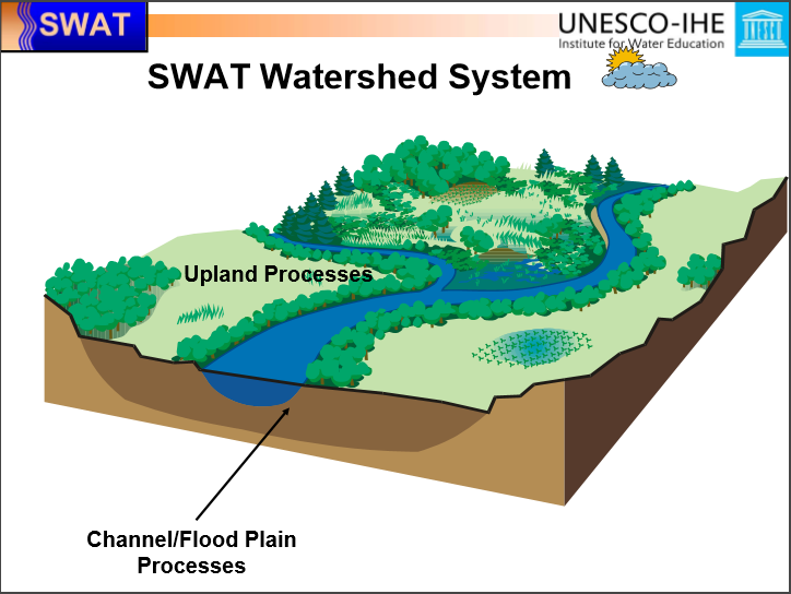
| SWAT |
Soil and Water Assessment Tool (SWAT) is a river basin scale model developed to quantify the impact of land management practices in large, complex watersheds. |
| WEPP |
The Water Erosion Prediction Project (WEPP) model is used to predict erosion on hillslopes and small watersheds. |
| WHAEM2000 |
WHAEM2000 is a US EPA analytic element model for groundwater and geohydrology designed to facilitate capture zone delineation and protection area mapping. |
| WMS |
The Watershed Modeling System (WMS) is a modeling system for watershed hydrology and hydraulics. WMS is capable of automated delineation of sub-watershed boundaries and flood extent, and includes graphic display options to aid in understanding the drainage characteristics of terrain surfaces as well as several computation features. |
| Habitat and Population Modeling |
| CWHR |
CWHR is a model of potential wildlife habitat in California that aids in resource conservation, planning, and predictive modeling |
| PATCH |
PATCH is a physical model that provides population viability modeling for territorial terrestrial vertebrate species. |
| RAMAS-CAST |
RAMAS-CAST provides functionality for the display and statistical characterization of disease clusters. |
| RAMAS-ECOTOX |
RAMAS Ecotoxicology is a data analysis package used for modeling population-level ecological risk assessments. |
| RAMAS-GIS4.0 |
RAMAS GIS links GIS to an ecological model for use in population viability analysis with landscape-based data that incorporate changes in habitat into a meta-population and combine geographic and demographic data for risk assessments. |
| RAMAS MULTISPECIES |
RAMAS Multispecies links GIS to an ecological model allowing the user to incorporate landscape data in population viability analyses, incorporate changes in habitat into a meta-population model, combine geographic and demographic data for risk assessments, and compute the Multispecies Conservation Values (MCV) across a study site. |
| SALMOD |
SALMOD is used to simulate the dynamics of freshwater anadromous and resident salmonid populations. |
| VORTEX |
VORTEX is a Population Viability Analysis model that is used to understand deterministic forces as well as genetic, environmental and genetic events on wildlife populations. |
| Water Quality |
| AGNPS |
AGNPS is a set of programs and models that allows for the prediction of non-point source pollution loading within agricultural watersheds and can be used to assist in the creation of Best Management Practices and other planning-related decisions. |
| ANALGWST |
This model can be used to predict 1, 2, and 3-dimensional solute transport in groundwater based on the findings of E.J. Wexler. |
| ANSWERS-2000 |
Answers-2000 is a physical model that can be used for the continuous-simulation of agricultural and urban ‘Best-Management-Practices’ in terms of sediment and nutrient delivery to surface runoff, and the associated leaching of nitrogen through the root zone. |
| BASINS |
BASINS is a physical model used for the evaluation of point and non-point source watershed pollution and TMDL modeling. |
| BATHTUB |
BATHTUB is a steady-state water quality model that simulates eutrophication-related water quality conditions in lakes and reservoirs. |
| BIOMOC |
BIOMOC is a physical model that simulates the 2-Dimensional transport of solutes through a water system as well as biodegradation rates and microbial growth. |
| BRANCH |
BRANCH is a physical model used to simulate flow in single or network of channels. |
| CORMIX |
CORMIX allows users to assess the mixing zones associated with continuous point-source discharges. |
| ECOFATE |
ECOFATE is a computer tool used for assessing chemical emissions from point and non-point source pollution sources for the purpose of developing Ecosystem-based risk assessments and determining potential effect on human health. |
| EMSOFT |
EMSOFT is a computer application that determines concentrations of contaminants in the soil over time, quantifies the transfer rate of the contaminants into the atmosphere and calculates the contaminant air concentrations. |
| EXAMS |
EXAMS is a computer modeling program that evaluates the fate, transport and exposure of pesticides, industrial materials and other leaching materials from disposal sites. |
| GWLF |
GWLF is a watershed loading model developed to assess non-point source flow and sediment and nutrient loading from urban and rural watersheds. |
| HSCTM2D |
HSCTM2D is a two-dimensional hydrodynamic model that is used to simulate surface water flow, sediment and contaminant transport. |
| HSPF |
HSPF simulates watershed hydrology and water quality for toxic and organic pollutants and can be used to model fate and transport in one-dimensional stream channels. |
| HST3D |
HST3D models three-dimensional ground water flow and associated heat and solute transport. |
| LISEM |
LISEM is a soil erosion model used to simulate the hydrology and sediment transport during and after rainfall events. The model is most ideally used as a research tool. |
| MODFLOW |
MODFLOW is used to simulate steady and unsteady flow in irregularly shaped flow and channel systems. |
| MODFLOWP |
MODFLOWP is an improved version of MODFLOW which can be used to simulate steady and unsteady flow in irregularly shaped flow and channel systems while incorporating non-linear regression techniques. |
| PATRIOT |
PATRIOT provides for the simulation of pesticide movement in unsaturated soil systems within and immediately below the plant root zone. |
| PHREEQC |
PHREEQC is a computer program used to perform a variety of low-temperature aqueous geochemical reactions. |
| SLAMM |
SLAMM is an urban watershed pollutant source area identification and management tool. |
| SWAT |
Soil and Water Assessment Tool (SWAT) is a river basin scale model developed to quantify the impact of land management practices in large, complex watersheds. |
| QUAL2EU |
QUAL2EU is a steady state model and planning tool used for evaluating conventional pollutants in branching streams and well mixed lakes. |
| WASP |
WASP is a model used to assess contaminant fate and transport in surface waters. |

/Image2218.gif)
/Image2219.gif)
/Image2214.gif)
/Image2217.gif)
/Image2215.gif)
/Image2221.gif)
/Image780.gif)
/Image2457.gif)
/Image1176.gif)
/Image1177.gif)
/Image1179.gif)
/Image1178.gif)
