戻る<1|2|3|4|5|6|7|8|9|10|11|12|13|14|15<
|
配付プリント等 |
補足説明 |
|
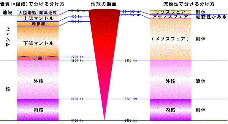
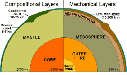
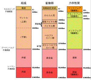
earth structure - The compositional and mechanical layers of the earth. 〔Visionlearning, Inc.によるViosionlearningの中の『Earth Structure』から〕 左側は化学的性質の違いにより、右側は物理的性質(特に硬さ)の違いにより分けられている。つまり、地殻+マントル最上部=リソスフェア(プレート)。プレートの厚さは100〜150km程度。 |
〔産業技術総合研究所 地質調査総合センターによる地質図のホームページの『日本の地質を知るページ』から〕 |
〔フリー百科事典『ウィキペディア(Wikipedia)』の『メソスフェア』から〕 |
大陸 | 海洋 | ||||
|
30km ↓ |
(6km/s) |
|
||
(7km/s) |
7km ↓ |
(プレート) |
|||
(7km/s) |
|||||
(8km/s) |
↑ 80km ↓ |
||||
|
↑ 120km ↓ |
(8km/s) |
|||
(7.8km/s) |
|
||||
(7.8km/s) |
|
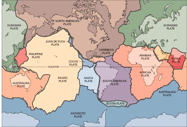
〔面積が大きい順(下の表を参照)〕 1)太平洋プレート Pacific Plate 2)ユーラシアプレート Eurasian Plate 3)北アメリカプレート North American Plate 4)アフリカプレート African Plate 5)南極プレート Antarctic Plate 6)オーストラリアプレート Australian Plate 7)南アメリカプレート South American Plate 9)ナスカプレート Nazca Plate 10)インドプレート Indian Plate Plate 11)フィリピン海プレート Philippine Sea Plate 12)アラビアプレート Arabian Plate 13)カリブプレート Caribbean Plate 14)ココスプレート Cocos Plate 16)スコシアプレート Scotia Plate 23)ファンデフカプレート Juan de Fuca Plate |
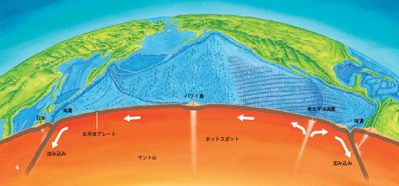
〔W. Jacquelyne Kious and Robert I. TillingによるThis Dynamic Earth: the Story of Plate Tectonicsから〕 15枚のプレート。プレートテクトニクスは、これらのプレートが水平運動を行うことによって起こる地質現象を説明するモデルである。地球内部の熱と物質は、とくにプレートの境界部に沿って地表へ流出するため、火山活動や地震の発生もこれらの境界部に多い。 |
|
(km2) |
|
1 | Pacific(太平洋プレート) | 103,280,000 |
2 | North American(北アメリカプレート) | 75,888,000 |
3 | Eurasian(ユーラシアプレート) | 67,811,000 |
4 | African(アフリカプレート) | 61,334,000 |
5 | Antarctic(南極プレート) | 60,916,000 |
Indo-Australian(インド・オーストラリアプレート) | ||
6 | Australian | 47,152,000 |
7 | South American(南アメリカプレート) | 43,617,000 |
8 | Somali | 16,667,000 |
9 | Nazca(ナスカプレート) | 15,630,000 |
10 | Indian(インドプレート) | 11,920,000 |
11 | Philippine(フィリピン海プレート) | 5,447,000 |
12 | Arabian(アラビアプレート) | 5,010,900 |
13 | Caribbean(カリブプレート) | 3,319,000 |
14 | Cocos(ココスプレート) | 2,860,000 |
15 | Caroline microplate(カロライナプレート) | 1,720,000 |
|
Scotia |
1,651,000 |
|
Fiji microplates | 1,144,000 |
18 | Burma microplate(ビルマプレート) | 1,110,000 |
19 | Tonga microplate(トンガプレート) | 962,000 |
20 | Mariana microplate | 364,000 |
|
Bismark microplate(North Bismarck/South Bismarck)(北ビスマルクプレート/南ビスマルクプレート) |
286,000 |
22 | Solomon microplate(ソロモン海プレート) | 254,000 |
23 | Juan de Fuca(ファンデフカプレート) | 252,000 |
24 | South Sandwich microplate | 166,000 |
25 | Easter microplate(イースタープレート) | 133,000 |
26 | Juan Fernandez microplate | 96,000 |
27 | Rivera microplate | 73,000 |
28 | Gorda microplate | 69,600 |
29 | Explorer microplate | 18,400 |
30 | Galapagos microplate | 12,000 |
W. K. Brown・K. H. Wohletzの両氏によるSFT
and the Earth's Tectonic Platesから。 リンクはフリー百科事典『ウィキペディア(Wikipedia)』。 |
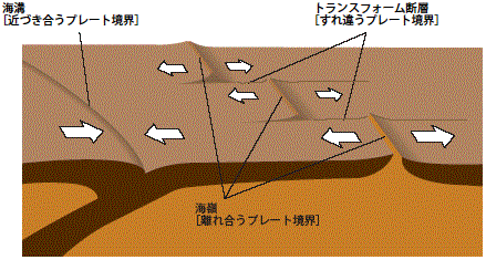
プレート運動 プレートの動きと境界 〔文部科学省地震調査研究推進本部の『地震の基礎知識』の中の『地震発生のメカニズムを探る』から〕 プレート境界は次の3種:
|
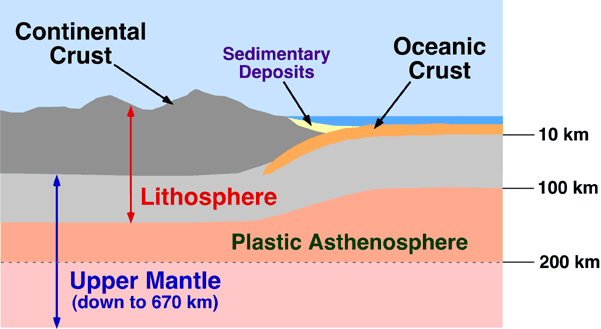
Figure 10h-2: Structure of the Earth's crust and top most layer of the upper mantle. The lithosphere consists of the oceanic crust, continental crust, and uppermost mantle. Beneath the lithosphere is the asthenosphere. This layer, which is also part of the upper mantle, extends to a depth of about 200 kilometers. Sedimentary deposits are commonly found at the boundaries between the continental and oceanic crust. 〔Michael Pidwirny氏によるPhysicalGeography.netの『FUNDAMENTALS OF PHYSICAL GEOGRAPHY』の『CHAPTER 10: Introduction to the Lithosphere』の中の『(h). Structure of the Earth』から〕 地殻(海洋地殻と大陸地殻)+マントル最上部=リソスフェア(プレート)。プレートの厚さは100〜150kmで、剛板(硬い板)のように振舞う。アセノスフェアは軟らかく(温度が高く、一部溶融しているらしい)、その上をプレートが滑るように水平移動する。 |
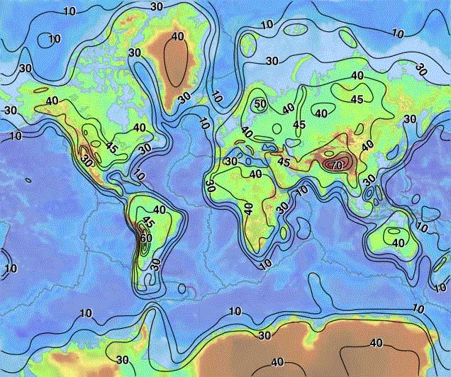
How Thick Is the Earth's Crust? 〔USGSによるEarthquake Hazardsの中の『The Earth's Crust』から〕 大陸地殻の平均の厚さは30〜40kmだが、70kmを越すところもある。一方、海洋地殻は10km以下。 |
参考 |
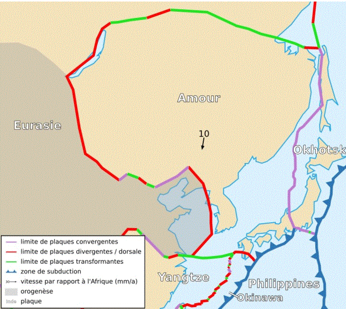
Map of the Amurian Plate and the adjacent tectonic plates (in French) Wikipediaの『Amurian Plate』から |