 |
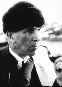
Alfred Lothar Wegener (1880-1930), the originator of the theory of continental drift. (Photograph courtesy of the Alfred Wegener Institute for Polar and Marine Research, Bremerhaven, Germany.) |
| 〔W. Jacquelyne Kious and Robert I. TillingによるThis Dynamic Earth: the Story of Plate Tectonicsから〕 | |
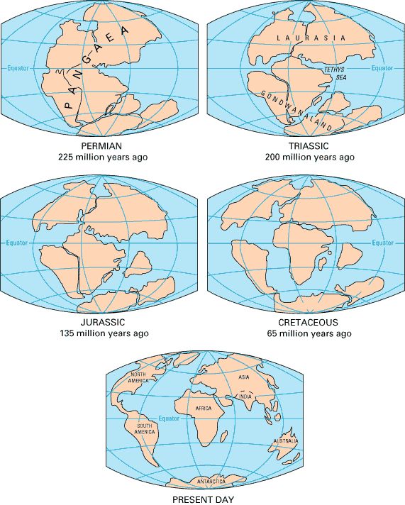 According to the continental drift theory, the supercontinent Pangaea began to break up about 225-200 million years ago, eventually fragmenting into the continents as we know them today. 〔W. Jacquelyne Kious and Robert I. TillingによるThis Dynamic Earth: the Story of Plate Tectonicsから〕 |
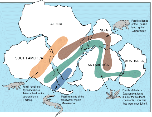 As noted by Snider-Pellegrini and Wegener, the locations of certain fossil plants and animals on present-day, widely separated continents would form definite patterns (shown by the bands of colors), if the continents are rejoined. 〔W. Jacquelyne Kious and Robert I. TillingによるThis Dynamic Earth: the Story of Plate Tectonicsから〕 |
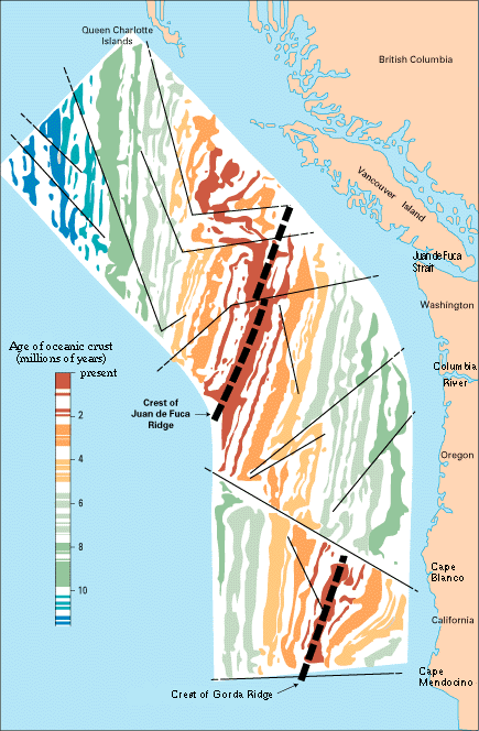 The center part of the figure -- representing the deep ocean floor with the sea magically removed -- shows the magnetic striping (see text) mapped by oceanographic surveys offshore of the Pacific Northwest. Thin black lines show transform faults (discussed later) that offset the striping. 〔W. Jacquelyne Kious and Robert I. TillingによるThis Dynamic Earth: the Story of Plate Tectonicsから〕 |
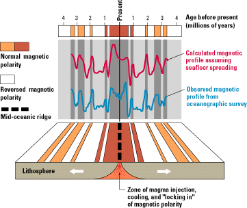 An observed magnetic profile (blue) for the ocean floor across the East Pacific Rise is matched quite well by a calculated profile (red) based on the Earth's magnetic reversals for the past 4 million years and an assumed constant rate of movement of ocean floor away from a hypothetical spreading center (bottom). The remarkable similarity of these two profiles provided one of the clinching arguments in support of the seafloor spreading hypothesis. 〔W. Jacquelyne Kious and Robert I. TillingによるThis Dynamic Earth: the Story of Plate Tectonicsから〕 |
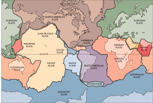 〔W. Jacquelyne Kious and Robert I. TillingによるThis Dynamic Earth: the Story of Plate Tectonicsから〕 大きなプレートは十数枚。 |
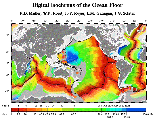 〔John C. Lahr氏によるHow to Build a Model Illustrating Sea-Floor Spreading and Subductionから〕 海洋底の生成年代。時代が若い海底は海嶺側に分布する。海洋地殻は海嶺で誕生し、海溝(沈み込み帯)でマントルへ沈み込んでいく、ことで説明される。 |
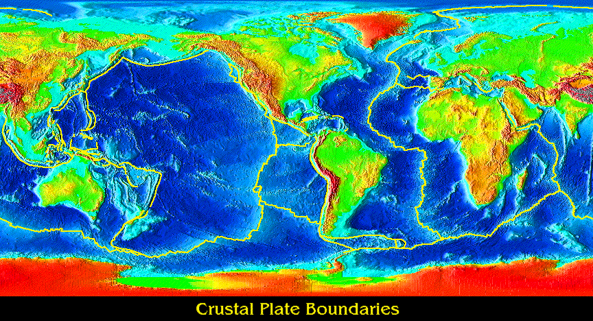 〔Rosanna L. Hamilton氏によるEarth's Interior & Plate Tectonicsから〕 黄色線はプレート境界を示す。 |
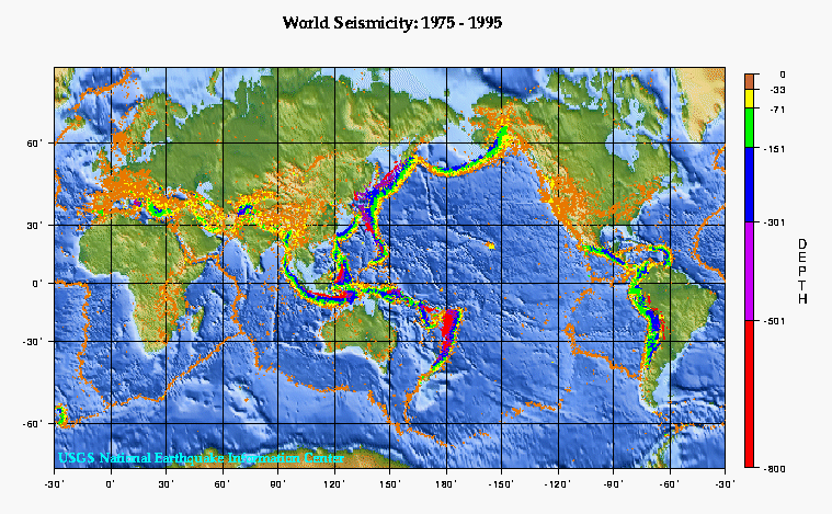 〔USGSによるEarthquake Hazards Programの中の『Earthquake Activity』から〕 震源分布。 |
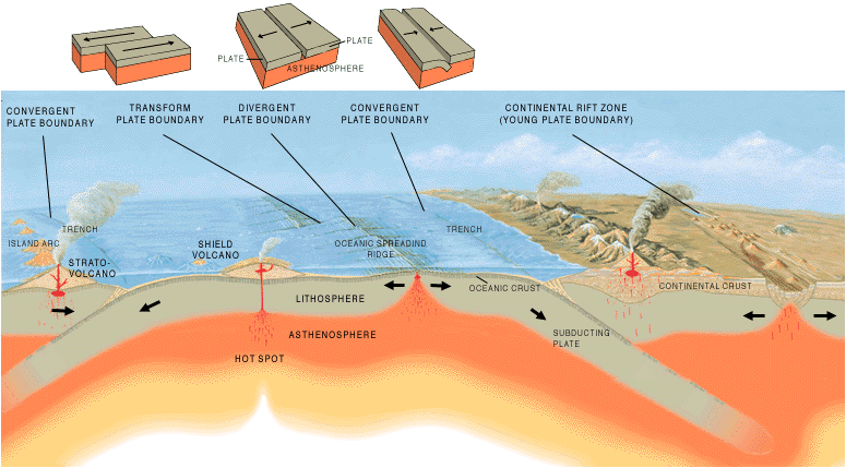 A cross section illustrating the main types of plate boundaries. Illustration by Jose F. Vigil from This Dynamic Planet -- a wall map produced jointly by the U.S. Geological Survey, the Smithsonian Institution, and the U.S. Naval Research Laboratory. 〔USGSのIndex of pubs.usgs.gov/gip/の『Earthquakes』の『Where Earthquakes Occur』から〕 プレート境界は、1)発散(divergent)、2)収束(convergent)、3)すれ違い(transform;トランスフォーム断層)の3つ。発散が起こっている場所の例は海嶺(ridge)とリフト(rift)、収束の例は海溝(trench)〔あるいはもっと広く沈み込み帯(subducting zone)〕。ホットスポットは、マントルの深い部分からプレートを貫いてプルームが上昇する場所(例えば、ハワイ島)。 |
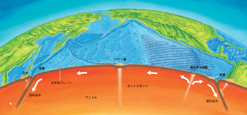 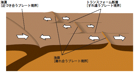 〔文部科学省地震調査研究推進本部の『地震の基礎知識』の中の『地震発生のメカニズムを探る』から〕 |
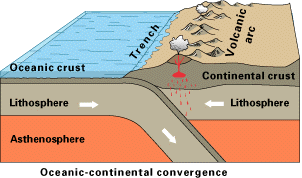 |
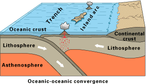 |
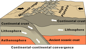 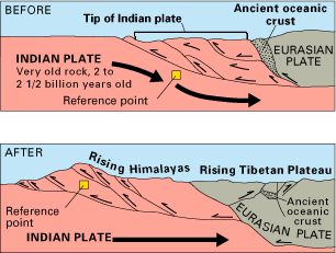 Cartoon cross sections showing the meeting of these two plates before and after their collision. The reference points (small squares) show the amount of uplift of an imaginary point in the Earth's crust during this mountain-building process. |
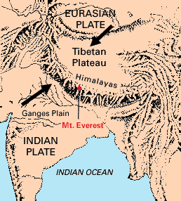 The collision between the Indian and Eurasian plates has pushed up the Himalayas and the Tibetan Plateau. 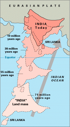 The 6,000-km-plus journey of the India landmass (Indian Plate) before its collision with Asia (Eurasian Plate) about 40 to 50 million years ago (see text). India was once situated well south of the Equator, near the continent of Australia. |
| 〔W. Jacquelyne Kious and Robert I. TillingによるThis Dynamic Earth: the Story of Plate Tectonicsから〕 | |
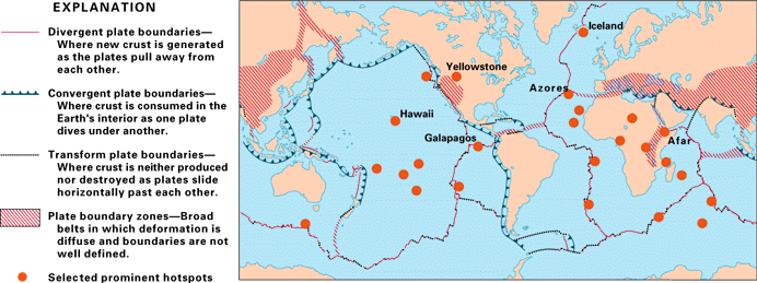 World map showing the locations of selected prominent hotspots; those labelled are mentioned in the text. (Modified from the map This Dynamic Planet.) 〔W. Jacquelyne Kious and Robert I. TillingによるThis Dynamic Earth: the Story of Plate Tectonicsから〕 |
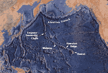 Map of part of the Pacific basin showing the volcanic trail of the Hawaiian hotspot-- 6,000-km-long Hawaiian Ridge-Emperor Seamounts chain. (Base map reprinted by permission from World Ocean Floor by Bruce C. Heezen and Marie Tharp, Copyright 1977.) 〔W. Jacquelyne Kious and Robert I. TillingによるThis Dynamic Earth: the Story of Plate Tectonicsから〕 |
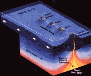 Artist's conception of the movement of the Pacific Plate over the fixed Hawaiian "Hot Spot," illustrating the formation of the Hawaiian Ridge-Emperor Seamount Chain. (Modified from a drawing provided by Maurice Krafft, Centre de Volcanologie, France). 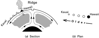 J. Tuzo Wilson's original diagram (slightly modified), published in 1963, to show his proposed origin of the Hawaiian Islands. (Reproduced with permission of the Canadian Journal of Physics.) |
| 〔W. Jacquelyne Kious and Robert I. TillingによるThis Dynamic Earth: the Story of Plate Tectonicsから〕 | |