/Image2265.gif) 南極での領有権主張(面積順)複数の主張で重複地域あり |
/Image2266.gif) |
| ウィキペディア(HP/2012/10)による『南極における領有権主張の一覧』から | |
|
|
最終更新日:2017年9月17日
| 南極大陸(Antarctica)関連の情報を集めている。 |
| リンク |
| 領土問題 |
/Image2265.gif) 南極での領有権主張(面積順)複数の主張で重複地域あり |
/Image2266.gif) |
| ウィキペディア(HP/2012/10)による『南極における領有権主張の一覧』から | |
/Image2264.gif) Guillaume & Dargaud(2011/12)による『Information about Antarctica』から |
| 南極観測 |
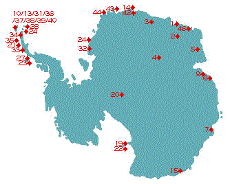
/Image2269.gif) Map shows the location of permanent Antarctic research stations Wikipedia(HP/2012/10)による『Research stations in Antarctica』から |
 |
|
||||||||||||||||||||||||||||||||||
| 〔国立極地研究所の中の『南極豆知識』から〕 | |||||||||||||||||||||||||||||||||||
| 地形 |
/Image2258.gif) 南極の地図 ウィキペディア(HP/2012/10)による『南極の地理』から |
/Image2257.gif) 氷床の下に眠る南極大陸の岩盤地形 ウィキペディア(HP/2012/10)による『南極大陸』から |
/Image2256.gif) Map of Antarctica and Southern Ocean geology.comによる『Antarctica Map』から |
| 地質 |
/Image2261.gif) Fig. 3. Gondwanaland showing the solid geology of Antarctica and neighbours (Veevers and Saeed, 2011, p. 714, 733), with Ferraccioli et al.'s (2011) interpretation of the boxed area, as detailed in Fig. A.1. Adelie(最初のeの頭に´) Craton from Finn et al. (2006). Letter symbols (1) in black indicate ages of outcrop, (2) in underlined black, provenance ages inferred from related detritus, and (3) in grey, provenance ages from the general distribution of detritus. The blank area between the cratons is interpreted as d+ fold belts. The blocks in the Miller Range (MR), Shackleton Range (SR), Coats Land (CL), and southern Prince Charles Mountains (SPCM) are shaded. Robert Glacier is shown as a rift (Veevers, 2009). The Ross, Delamerian, Lachlan, and New England Orogens are stippled, and the Ross-Delamerian granites are shown in black. CL = Coats Land; DML = Dronning Maud Land; EG = Eastern Ghats; GP = Grunehogna Province; NC = Napier Complex; PB = Prydz Bay; SPCM = southern Prince Charles Mountains; SR = Shackleton Range. |
/Image2262.gif) Fig. 22. Summary of results. On a base from Fig. 3, this figure summarises the results of our work in the 240゜E-0゜-015゜E sector. Ages and letter symbols (top right box) are modified from Veevers and Saeed (2011). Letter symbols (1) in black indicate zircon ages of igneous and metamorphic outcrop, and in bracketed black (West Antarctica) zircon ages in sedimentary rocks; (2) in underlined black, ages of ice-covered provenances inferred from related detritus; and (3) in grey, ages of ice-covered provenances from the general distribution of detritus. The oval areas south and east of Dronning Maud Land (DML) are labelled with details of the presumed ice-covered provenances; the other area of presumed ice-covered provenance, between the TAM and the Shackleton Mountains (SR), is marked by (Cに=を重ねた記号) denoting Cambrian archaeocyathan-bearing shale. The blocks in the Miller Range (MR), Shackleton Range (SR), Coats Land (CL), Pensacola-Thiel Mountains (PTM), and southern Prince Charles Mountains (PCM) are shaded. Robert Glacier is shown as a rift (Veevers, 2009). Letter symbols (lower left box) indicate ages of sedimentary cover in the interior or in the passive margin. The blank area between the cratons is interpreted as d+ fold belts. The box on the lower left corner contains a key to the elements of the basement provinces (boxed central area), in which Te = effective elastic thickness of the lithosphere; details in Fig. A.1. CL = Coats Land; DML = Dronning Maud Land; EG = Eastern Ghats; GP = Grunehogna Province; NC = Napier Complex; PB = Prydz Bay; PCM = Prince Charles Mountains; SR = Shackleton Range; Te = effective elastic thickness of the lithosphere (flexural rigidity). |
| Veevers & Saeed(2012)による『Age and composition of Antarctic sub-glacial bedrock reflected by detrital zircons, erratics, and recycled microfossils in the Ellsworth Land-Antarctic Peninsula-Weddell Sea-Dronning Maud Land sector (240゜E-0゜-015゜E)』から | |
/Image2267.gif) Orogens and Kuungan Orogens. |
/Image2268.gif) Reconstruction showing final stages of assembly of Gondwana, 550 Mya. |
| Wikipedia(HP/2012/10)による『Gondwana』から | |
/Image2260.gif) 高橋(1987)による『東南極セールロンダーネ山地の地質調査』から |
| 資源 |
/Image2255.gif) 南極大陸の鉱石鉱物,金属,石油,石炭,天然ガスの分布と主な観測基地 (財団法人日本極地研究振興会創設40周年記念冊子「南極大陸」(2004年)より) 白瀬日本南極探検隊100周年記念プロジェクトによる『Q.南極に地下資源はある?』から |
| 南極隕石 |
/Image2273.gif) 7. 南極隕石の集積 南極隕石は、内陸の山脈周辺部に限って見つかります。こうした南極内陸に出現する山脈の周辺は、共通して、氷床面が雪面でなく、裸氷が露出しています。これは降雪が地下で厚密して氷になったのが、氷床流動に伴い、内部から湧き上がってきているものです。通常は、氷床は内陸から沿岸へ向けて流動しており、最後は沿岸で氷山となり、流出します。しかし、内陸に山脈が出現する地域では、山脈の存在により、局所的な氷床の上昇流が生じます。また、この地域は「かたば風」が強く上昇してきた氷は連続的に昇華していき、よく上昇量と昇華量とがほぼ釣り合っています。この結果、内部から湧きあがってきた隕石が表面に残ると考えられています。こうしたことから、隕石の集積モデルが提出されています。 南極隕石ラボラトリの『南極隕石について』から |
|
/Image2274.gif) 南極の氷が隕石を集めるふしぎなしくみ 隕石が南極にたくさん降るわけではない 日本隊が発見した南極氷床の隕石集積機構 南極で氷床の上に落ちた隕石は氷の中に閉じこめられ、氷とともに海に向かって流れていく。しかし、山脈などで氷の流れがとめられた場所では、氷は風にけずられたり、昇華して消えていくのだ。閉じこめられた隕石は氷の表面に取り残されてしまう。 昭和基地に近いやまと山脈に、100万年以上かかって千キロ四方の広さの氷が一ヶ所に集まり、消えていく場所があったのだ。 黒い隕石は氷の上でよく目立つので、すぐに見つけられる。また氷に守られ、風化してしまうこともない。こうして保存状態がよい大量の隕石が、一つの場所で大量に採取できるのだ。 南極サイエンス基地の『南極隕石』の『隕石はどうして一カ所に集められるのか?』から |
/Image2275.gif) 太陽系の歴史の研究を大きく進歩させた「南極隕石」 南極サイエンス基地の『南極隕石』の『太陽系の誕生を知っている隕石 日本が発見した南極隕石のふしぎ』から |
| 国立極地研究所(HP/2012/10)による | |
/Image2270.gif) 南極隕石が収集された場所を示した地図 |
/Image2272.gif) 落下した隕石が氷河によって運ばれ山脈の前に集積する機構(de版の図) |
| ウィキペディア(HP/2012/10)による『南極隕石』から | |