ウィキペディアによる『デリー首都圏』(2019/1/23)から |
|
|
最終更新日:2019年1月23日
| 全般 |
|
自然 | 問題 | その他 |
| リンク|
行政区分| |
人口|
経済| |
地理| 地質| エネルギー資源| 鉱物資源| |
河川連結計画| |
| ここには、インド(India、Republic of India)における主に資源(Resource)・地球科学(Earth Science)・環境(Environment)に関連する情報を集めている。 |
| リンク |
| 全般 |
|
自然 | 問題 | その他 |
|
全般|
行政区分| 組織・機関| |
人口| 経済|貿易| 産業|農業| |
地理| 地質|デカン| 資源エネルギー| |
カースト| カシミール問題| |
観光|
ガンジー| 河川連結計画| その他 |
| 行政区分 |
ウィキペディアによる『デリー首都圏』(2019/1/23)から |
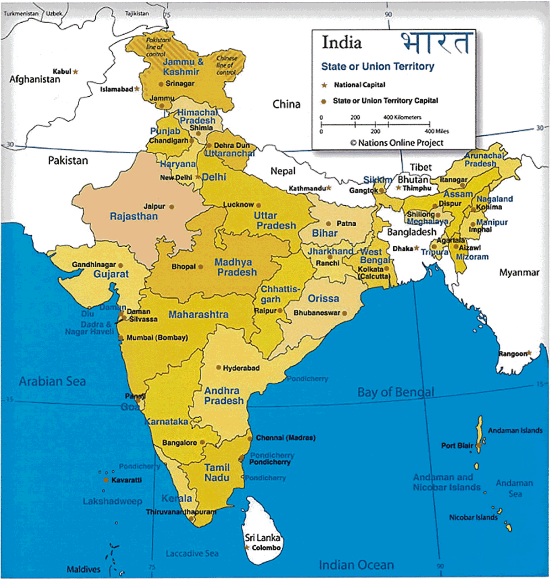 インドの州レベルの行政区画 資料:http://www.nationsonline.org/oneworld/ india_map.html |
|
| 国土交通省国土政策局総務課企画室による各国の国土政策の概要の『インド(India)』(2017?)から | |
/Image161.gif) インドの地方行政区画、28州と7連邦直轄領 |
28州 連邦直轄領 |
| ウィキペディア(HP/2013/9)による『インドの地方行政区画』から | |
/Image1093.gif) インドの行政区分 原子力百科事典ATOMICA(2006)による『インドの国情およびエネルギー政策』から |
| 人口 |
|
|
| Yukinosukeの米国株投資による『世界の人口予測|2024年までにはインドが中国を抜いて世界第1位に。アメリカは引き続きバランスのとれた人口増が続く。』(2018/2/11)から | |
本川 裕による社会実情データ図録の『中国とインドの超長期人口推移』(2016/9/25)から |
/Image1571.gif) Map showing the population density of each district in India. Wikipedia(HP/2012/3)による『Demographics of India』から |
/Image1570.gif) (注)主要な17 州の数値のみを掲げた。なおウッタル・プラデーシュ、マッディヤ・プラデーシュ、ビハール3 州の1991-2001 年間の増率は、それぞれ2000 年に分離したウッタラカンド州、チャッティースガル州、ジャールカンド州を含めての数値である。 (出所)Census of India 2001 Data Online およびCensus 2011, Provisional PopulationTotals(pov_popu_ppt_2011.pdf) いずれもURL http://www.censusindia.gov.in/ 佐藤(2011)による『2011 年センサス速報値の発表』から 2011年3月1日現在のインドの総人口は、12億1,019 万人。 |
/Image1569.gif) 本川(2010)による『中国とインドの超長期人口推移』から |
/Image1099.gif) onlineenglish(2007)の中の『Free IELTS Writing Task 1 (Descriptive Report)』から |
| 経済 |
|
|
|
|
|
|
| 不破雷蔵によるガベージニュースの『主要国のGDPをグラフ化してみる(最新)』(2019/1/1)から | |
|
|
| インターネットで読み解く!による『中国に続きインドにも抜かれるGDP推移グラフ [BM時評] 』(2011/9/25)から | |
| 地理 |
National Geographic Society・National Geographic Partners, LLC.・Nikkei National Geographic Inc.による『宇宙から見た夜の地球、4年でこれだけ変化した インドは明るくなり、シリアは暗くなった、北朝鮮は?』(2017/5/3)から |
National Geographic Society・National Geographic Partners, LLC.・Nikkei National Geographic Inc.による『宇宙から見るインドの夜景』(2012/11/22)から |
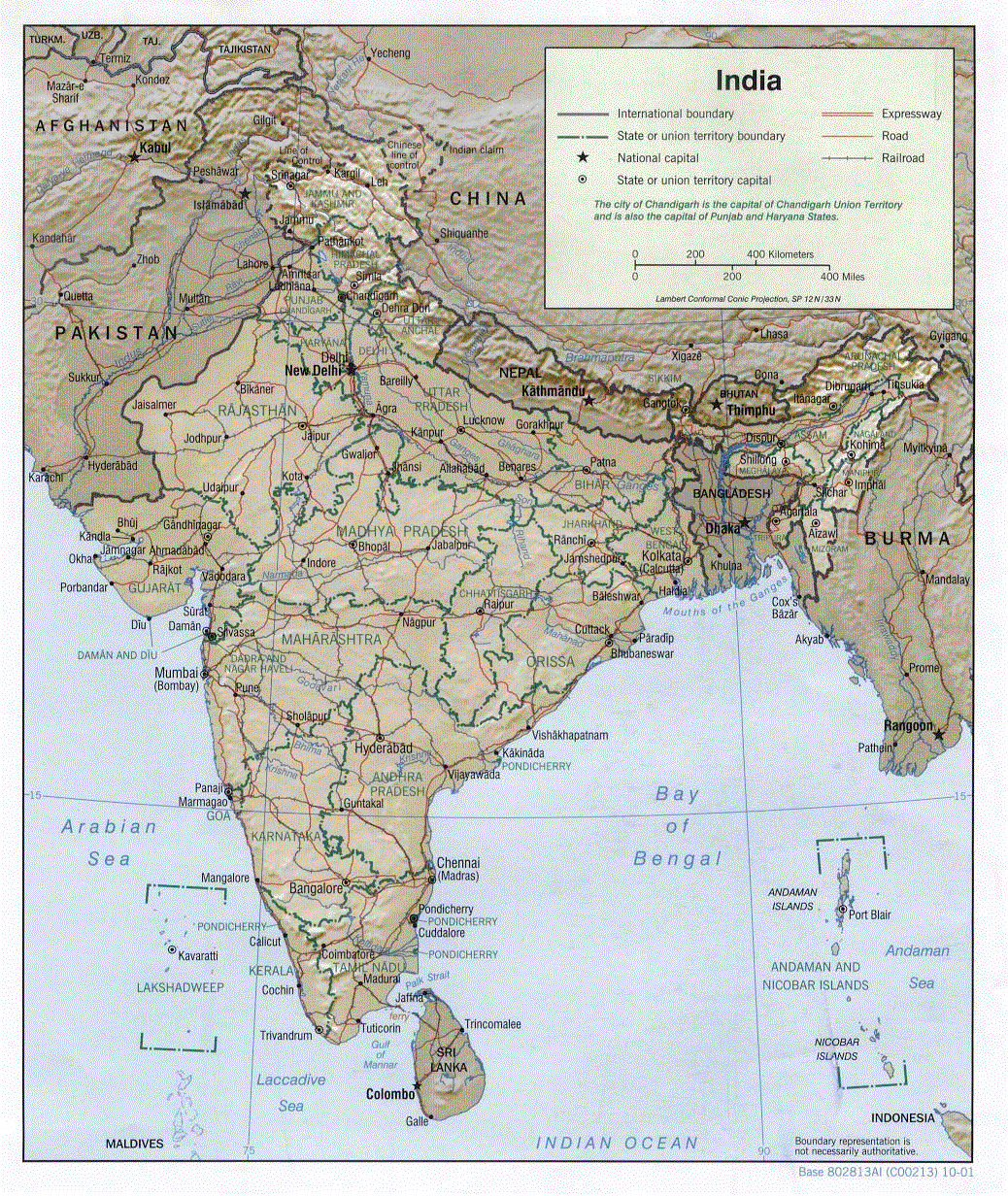 The University of Texas at AustinのUniversity of Texas Librariesの『Perry-Castaneda(nの頭に~) Library Map Collection』の中の『India (Shaded Relief) 2001 (273K)』から |
| 地質 |
/Image1127.gif) Geological Map of India |
/Image1125.gif) Map Showing distribution of Geological Provinces in India |
| Geological Survey of India(HP/2011/10)による『PRECAMBRIAN GEOLOGY OF INDIA』から | |
/Image1124.gif) Map of chronostratigraphic divisions of India Wikipedia(HP/2011/10)による『Geology of India』から |
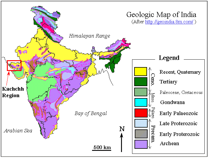 〔応用地質(株)による『地震防災』の中の『インド・グジャラート地震被害調査報告』から〕 |
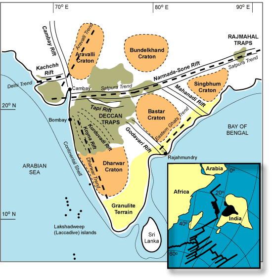 Figure 2. Map showing the approximate boundaries of the Precambrian cratons making up the Indian shield (e.g., Pandey & Agrawal, 1999; Naqvi & Rogers, 1987), the granulite terrain, the Precambrian structural trends (heavy broken lines), rift zones crossing peninsular India (e.g., Biswas, 1987), and the present outcrop areas of the Deccan and Rajmahal flood basalts. Inset shows the breakup of the Seychelles microcontinent, situated along the northern tip of the Mascarene Plateau (black), from India, soon after the Deccan flood basalt episode (after Norton and Sclater, 1979; Mahoney, 1988). The Koyna and Kuruduvadi “rifts” have been proposed based on gravity surveys and may represent humps of the granitic basement rather than rifts. |
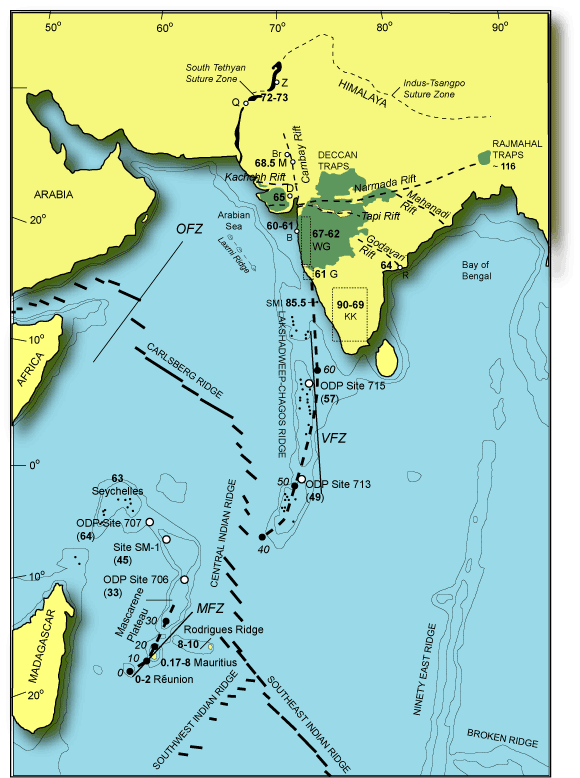 Figure 3. Prominent structural-tectonic features of southern Asia and the Indian Ocean basin (based on Mahoney et al., 2002). Abbreviations for localities are: Q, Quetta; Z, Zhob; B, Barmer, M, Mundwara; D, Dhandhuka; B, Bombay; R, Rajahmundry. WG is the Western Ghats region (ages from Venkatesan et al., 1993 and others). ~ 64 Ma age for Rajahmundry basalts is from Baksi (2001a). G, ~ 61 Ma Goa dykes (Widdowson et al., 2000). KK, ~ 90-69 Ma Karnataka-Kerala dykes (e.g., Radhakrishna et al., 1994; Anil Kumar et al., 2001). SMI are the St. Mary's Islands volcanics (85.5 Ma, Pande et al., 2001), part of the Indo-Madagascar CFB which in India is otherwise represented by the KK dykes. The associated flood basalt lavas are not represented or known in India; there are many Precambrian dyke swarms throughout southern India as well. 72-73 Ma ages for Quetta and Zhob rocks and 65 Ma age for Dhandhuka-Botad lavas are from Mahoney et al. (2002), as also the modelled hotspot track showing expected ages in Ma. Note the rift zones underlying the Deccan, and the absence of any triple junction. OFZ, Owen Fracture Zone; MFZ, Mauritius Fracture Zone; VFZ, Vishnu Fracture Zone. |
|
In conclusion, a non-plume, plate-tectonic model involving continental breakup and related mantle convection and decompression melting, is suitable for the Deccan. If radial, focused flow of the upper mantle occurs (instead of vertical flow as in the plume model), a potentially unlimited volume of the mantle is available for processing. The plume model was proposed for the Deccan more than 30 years ago, when little was known about the Deccan and about the plume mode of convection. Today we know a lot more about the Deccan, and the plume model becomes less tenable as our knowledge grows. The originators and champions of the plume model had little or no personal knowledge of the Deccan, and their broad generalizations should have been put to critical tests by regional experts on the Deccan. The tendency has been to assume a plume origin and infer the plume properties and characteristics based on whatever is required by the observations, but if volatiles, mantle fertility, continental geology, and dynamic, evolving plates are considered, one no longer needs mantle plumes (Sheth, 2005b). The new voices asking for new explanations (e.g., http://www.mantleplumes.org/Deccan2.html) are a good sign. The plume model for the Deccan has been around for over thirty years, and has failed. A new, scientifically tenable non-plume model for the Deccan could be rapidly developed if only a few of the many Deccan/flood basalt enthusiasts share the task. We live in interesting times. 〔www.MantlePlumes.orgの『India』の中の『Hetu Shet氏によるDeccan Traps: The Deccan beyond the plume hypothesis』から〕 |
|
| エネルギー資源 |
/Image1094.gif) 1次エネルギー供給構成(2008年) 田舎の無電化地域で多く利用する薪や動物のフンなどのバイオマス(生物資源)が1次エネルギー供給量の4分の1を占める 出所:国際エネルギー機関 |
/Image1095.gif) 発電電力量構成(2008年) 石炭・石油・天然ガスによる火力発電が発電電力量の約8割を占める。電力不足が深刻なインドでは今後も火力発電が主力になる見通しだ 出所:国際エネルギー機関 |
/Image1096.gif) 「ジャワハルラル・ネール・ナショナル・ソーラー・ミッション(JNNSM)」の目標 中央政府は「ジャワハルラル・ネール・ナショナル・ソーラー・ミッション(JNNSM)」を始動、太陽光発電システムの導入を促進する。固定価格買い取り制度などを活用して2022年までに2000万kW(系統連系)を導入するのが目標である |
|
| 日経エコロジーレポート(HP/2011/6)による『インドの再生可能エネルギー』から | |
/Image1097.gif) インドの一次エネルギー消費推移 /Image1098.gif) インドの電力需給 石田(2006)による『インドのエネルギー情勢・政策動向』から |
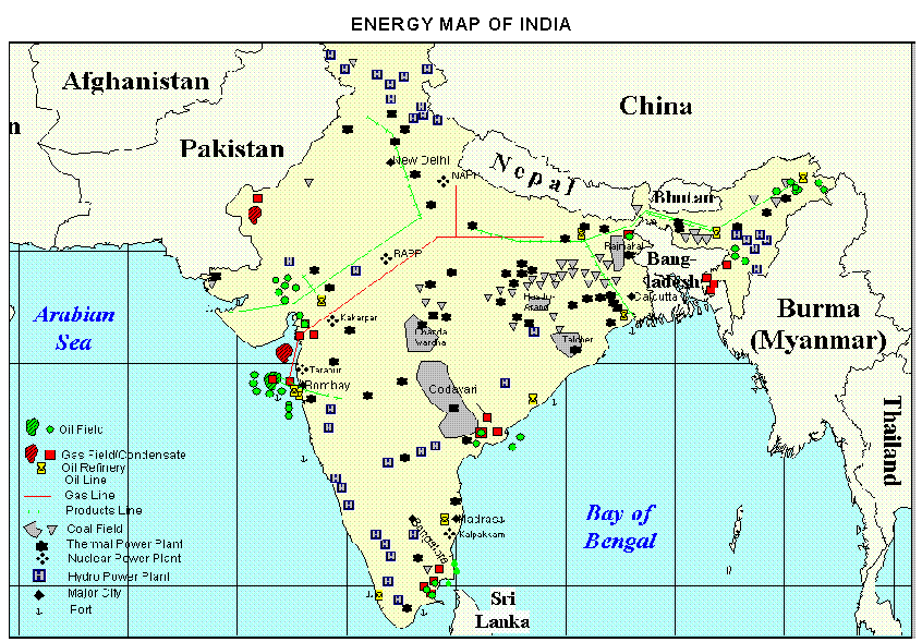 The University of Texas at AustinのUniversity of Texas Librariesの『Perry-Castaneda(nの頭に~) Library Map Collection』の中の『India - Energy Map from "India: An Energy Sector Overview", 1997, U.S. Energy Information Administration (55K)』から |
| 鉱物資源 |
| 河川連結計画 |
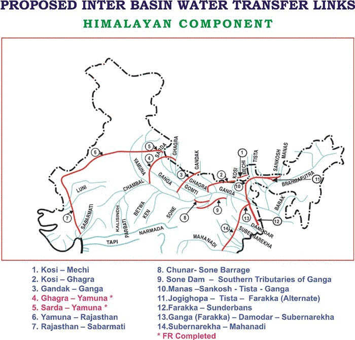 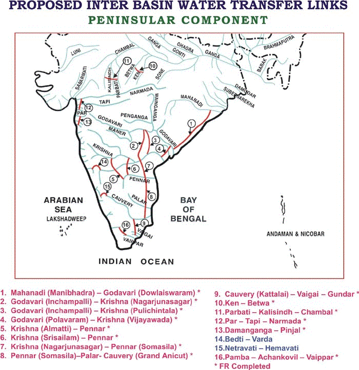 〔National Water Development Agency (NWDA)の『National Perspective Plan (NPP)』から〕 |