The Geoid ...
is that equipotential surface of the Earth gravity field that
most closely approximates the mean sea surface. At every point
the geoid surface is perpendicular to the local plumb line. It
is therefore a natural reference for heights - measured along
the plumb line. At the same time, the geoid is the most graphical
representation of the Earth gravity field.
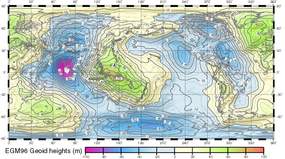
The geoid surface is described by geoid heights that refer to
a suitable Earth reference ellipsoid. Geoid heights are relative
small.The minimum of some -106 meter is located at the Indian
Ocean. The maximum geoid height is about 85 meter. The figure
below shows a global map with geoid heights of the EGM96 gravity
field model, computed relative to the GRS80 ellipsoid.
〔Deutsches
Geodatisches Forschungsinstitut (DGFI)によるGeodIS(Geodesy
Information System)の中の『The
Geoid』から〕
地球楕円体からのジオイドの高さを示す。 |


