|
|
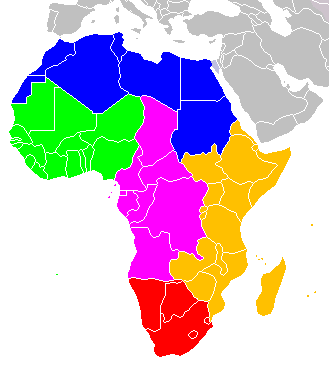 国際連合によるアフリカの区分 青色は北アフリカ、黄緑色は西アフリカ、紫色は中部アフリカ、オレンジ色は東アフリカ、赤色は南部アフリカ。 |
|
| ウィキペディアによる『サブサハラアフリカ』(HP/2019/2/5)から | |
ウィキペディアによる『アフリカの地理』(HP/2019/2/5)から |
|
|
最終更新日:2019年4月27日
| 全般 | 地理・歴史 |
社会・産業 | その他 |
| リンク| | 地理|人口|
歴史| |
経済|GDP|
資源エネルギー| |
地質|アフリカプレート|大地溝帯|
植民地|奴隷貿易| 紛争| |
| ここには、アフリカ(Africa)における主に資源(Resource)・地球科学(Earth Science)・環境(Environment)に関連する情報を集めている。 |
| 全般 |
|
西部 | 東部 | 中部 |
|
| リンク |
| 全般 | 地理・歴史 |
社会・産業 | その他 |
| 全般|
機関・組織| サブサハラ| |
地理|人口|
歴史| |
資源エネルギー| |
地質/プレート運動|
観光| 植民地|奴隷貿易| 紛争| その他 |
| 地理 |
|
|
 国際連合によるアフリカの区分 青色は北アフリカ、黄緑色は西アフリカ、紫色は中部アフリカ、オレンジ色は東アフリカ、赤色は南部アフリカ。 |
|
| ウィキペディアによる『サブサハラアフリカ』(HP/2019/2/5)から | |
ウィキペディアによる『アフリカの地理』(HP/2019/2/5)から |
/Image591.gif) 衛星画像 |
/Image592.gif) アフリカの地形(NASA) |
/Image593.gif) 現在のアフリカ |
|
/Image594.gif) 言語 アフリカの語族および主要なアフリカ言語の分布を示す地図。 |
/Image595.gif) 言語 多くのアフリカ諸国では1つ以上の公用語を話す。 |
| ウィキペディア(HP/2014/4)による『アフリカ』から | |
| 人口 |
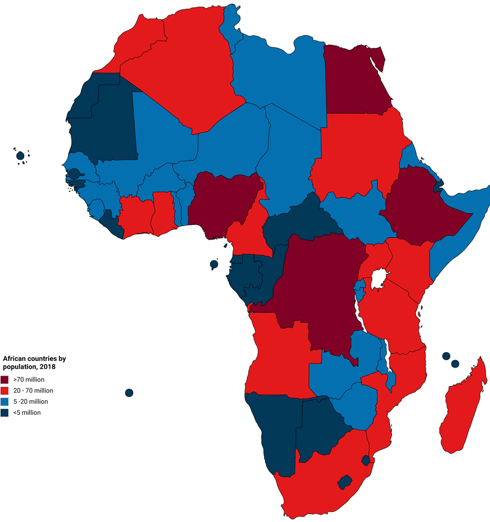 African countries by population, 2018 |
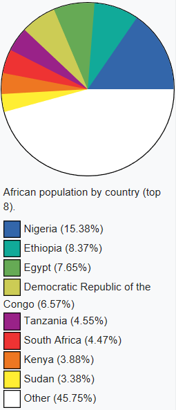 African population by country (top 8) |
| Wikipediaによる『List of African countries by population』(HP/2019/2/4)から | |
|
|
| 損保ジャパン日本興亜アセットマネジメント(株)による『パン・アフリカ株式ファンド』(2018/5)から | |
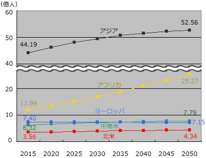 アフリカの将来の人口推移予測 |
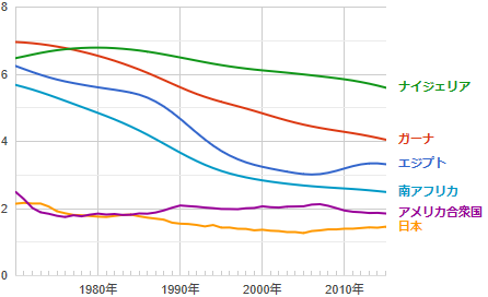 出生率 データ元: 世界銀行 |
| 日本と世界の統計データによる『アフリカ諸国の将来の人口推移予測』(2017?)から | |
| 歴史 |
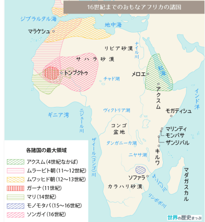 16世紀までのおもなアフリカの諸国地図 世界の歴史まっぷによる『16世紀までのおもなアフリカの諸国地図』(2018/12/14)から |
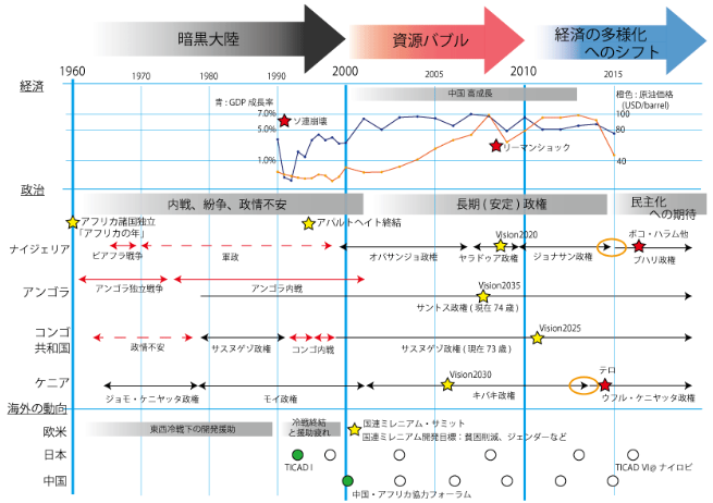 アフリカの近現代史 伊関洋介によるAfropickの『アフリカの近現代史② 2000~現在』(2018/6/18)から |
| 経済 |
/Image596.gif) National GDP per capita ranges from wealthier countries the north and south to poorer states in the east. These figures from the 2002 World Bank are converted to US dollars. Wikipedia(HP/2014/4)による『Economy of Africa』から |
| GDP |
|
|
| エルディターズによる母ちゃん!俺、ゲーム作るわ!の『アフリカの国別GDPランキングを使ってアフリカ経済を解説!』(2018/7/12)から | |
|
アフリカGDP上位国 |
| 損保ジャパン日本興亜アセットマネジメント(株)による『パン・アフリカ株式ファンド』(2018/5)から | |
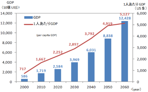 アフリカの名目GDP及び1人当たりGDPの推移・見通し(2000~2060年) Resource: ”Africa 50 years’ Time”, African Development Bank、2011 アフリカビジネス振興サポートネットワーク(ABネット)による『アフリカ経済の概況』(2017/12/15)から |
|
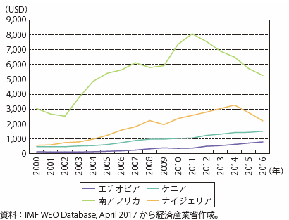 第Ⅰ-4-5-1-2図 アフリカ主要国の一人当たり名目GDP |
| 経済産業省による通商白書2017の『1.アフリカの経済概略』(2017?)から | |
| 資源エネルギー |
/Image584.gif) 図1 アフリカにおける国別原油生産分布とフロンティア |
/Image585.gif) 図4 アフリカにおける国別天然ガス生産分布とフロンティア |
| 竹原(2014/3)による『Africa Oil Weekへの参加とサブサハラの注目エリアについて』から | |
/Image583.gif) |
/Image586.gif) 今、分かっている世界におけるアフリカ諸国の資源埋蔵量率 |
| JOGMECによる『広報誌特集:資源大陸アフリカの全貌』(2013/3)から | |
/Image587.gif) 1.アフリカの資源の賦存状況 |
|
/Image588.gif) 8.石油・天然ガス埋蔵量及び生産量 |
|
| 経済産業省資源エネルギー庁資源・燃料部鉱物資源課(2009/10)による『アフリカの鉱物資源の重要性と我が国の取組み』から |
| 地質 |
Kareem Anenによる『The surface geology of Africa』(2015/11?)から |
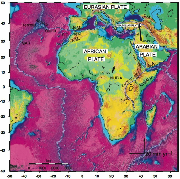 Figure 1: On Nubia's western flank, extension is occurring at the Middle Atlantic (MAR) and Terceira ridges, which then transitions via a triple junction at the Azores (between Africa, Eurasia, and North America), to the Gloria transform fault (Serpelloni et al., 2007)(McClusky et al., 2003). This fault extends to the Mediterranean, where continental lithosphere comes into play, and the tectonic interactions become complex due to the collision of Africa and Eurasia (Vernant et al., 2010). Modified after McClusky et al., 2003. |
|
| Taylor Combaluzierによる『The North West Region of the Nubian Plate』(2011?)から | |
| アフリカプレート |
/Image589.gif) Fig. 1. Present day extent of the African plate. Age of oceanic crust (this study) and ages of continental basement and sedimentary cover (Persits et al., 2002) are draped on shaded relief of free air gravity anomaly (Sandwell and Smith, 2009). The white region surrounding present day coastlines is interpreted as extended continental crust and its oceanward limit is considered the continent-ocean boundary (COB). Neighboring tectonic plates are: Eurasia (EUR), Arabia (AR), India (IND), Australia (AUS), Antarctica (ANT), South America (SAM) and North America (NAM). Other abbreviations: GA―Gulf of Aden, NSB―North Somali Basin, RS―Red Sea, OB―Oman Basin. Gaina et al.(2013/9)による『The African Plate: A history of oceanic crust accretion and subduction since the Jurassic』から |
| 大地溝帯 |
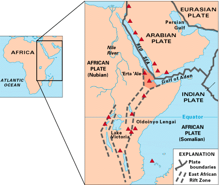 Map of East Africa showing some of the historically active volcanoes (red triangles) and the Afar Triangle (shaded, center) - a so-called triple junction (or triple point), where three plates are pulling away from one another: the Arabian Plate, and the two parts of the African Plate (the Nubian and the Somalian) splitting along the East African Rift Zone. (リンクはWikipedia) Kious & Tilling(1996/2)による『This Dynamic Earth: the Story of Plate Tectonics』から |
| 植民地 |
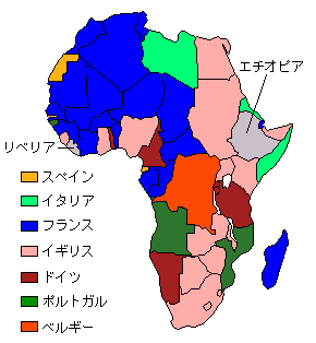 1912年のアフリカ ウィキペディアによる『アフリカ分割』(HP/2019/2/5)から |
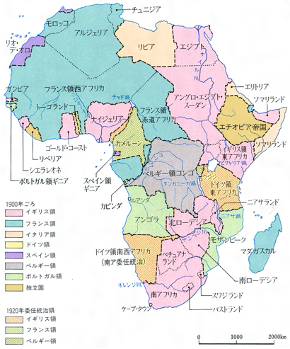 アフリカの植民地分割 コトバンクによる『アフリカ史』(HP/2019/2/5)から |
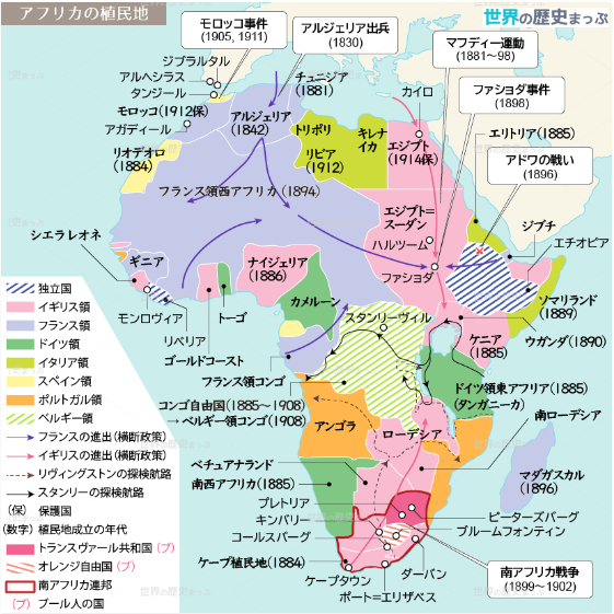 アフリカの植民地化地図 |
|
|
|
| 世界の歴史まっぷによる『アフリカの植民地化』(2019/1/16)から | |
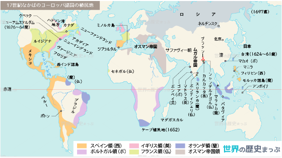 17世紀なかばのヨーロッパ諸国の植民地地図 世界の歴史まっぷによる『17世紀なかばのヨーロッパ諸国の植民地地図』(2018/11/29)から |
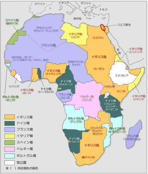 アフリカ分割 さわやか易(別館)による『帝国主義時代のアフリカ分割』(2016/5/1)から |
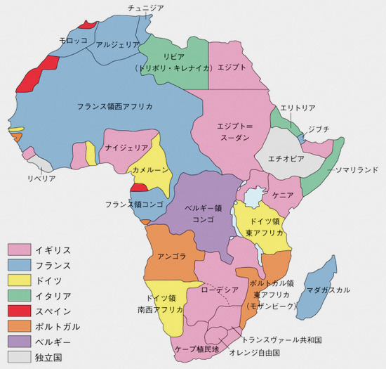 アフリカ分割 東大世界史講師によるHistory of Worldの『アフリカ分割に関する地図問題』(2016/1/13)から |
| 奴隷貿易 |
|
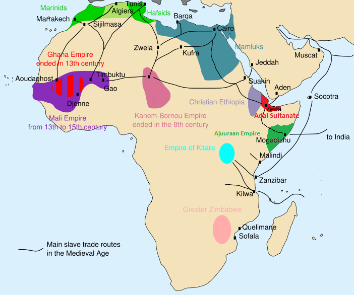 The main slave routes in medieval Africa The main slave routes in medieval Africa
Wikipediaによる『Slavery in Africa』(HP/2019/2/6)から |
| 紛争 |
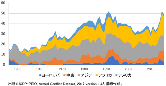 図1 現代の紛争はどこで起こっているか? |
表1 主要な武力紛争:アジアとアフリカ |
|
|
| 武内進一による『冷戦後アフリカの紛争と平和構築の課題―日本のアフリカ外交への示唆―』(2018/8/13)から | |