|
最終更新日:2018年12月15日
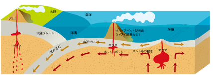
火山フロント |
Figure 1. Location of Setouchi volcanic belt (open stars), which extends for 〜600 km parallel to Nankai Trough and occupies present forearc regions, 〜80 km trenchward of Quaternary volcanic front (QVF). Setouchi volcanic belt was active at 15-13 Ma, largely synchronous with timing of backarc-basin formation in Shikoku basin and Japan Sea at 26-15 Ma and in early to middle Miocene, respectively. Subduction of such a young and hot Philippine Sea plate beneath southwest Japan resulted in partial melting of subducting slab. DSDP is Deep Sea Drilling Project. |
Figure: Distribution of Quaternary volcanoes Depths of subducting plates are based on Yokoyama et al. (editors), 1992 and Hasegawa et al., 2010. GLGArcs(HP/2014/6)による『Introduction to the landforms and geology of Japan』から |
Volcanic Front Fitcher,L.(2013/7)による(SEPM STRATA Society for Sedimentary Geology)による『Wilson Cycle Stage E - Arc Mountain Building』から |
火山噴火 |
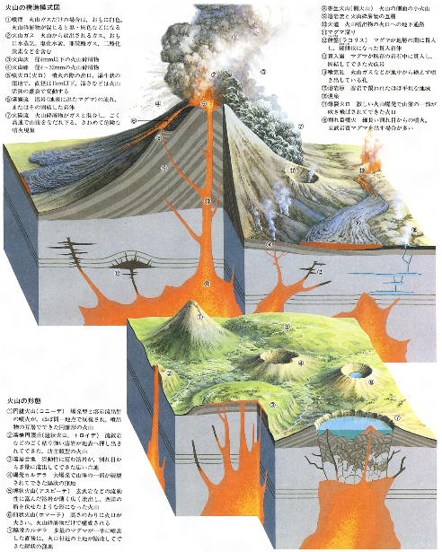
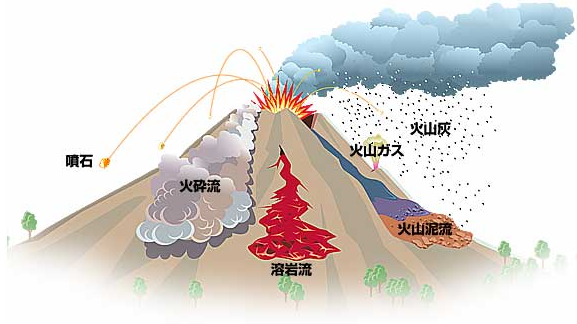
火山噴火 鹿児島県による『火山災害への備え』(2015/12/2)から |
火山爆発指数(Volcanic Explosivity Index、VEI)とは、1982年にアメリカ地質調査所のクリス・ニューホールChristopher G. Newhallとハワイ大学マノア校(英語版)のステフェン・セルフ (Stephen Self) が提案した火山の爆発規模の大きさを示す区分である。火山そのものの大きさではなく、その時々の爆発の大きさの指標である。 VEIの区分
ウィキペディア(HP/2015/5)による『火山爆発指数』から |
ウィキペディア(HP/2015/5)による『火山の一覧』から |
|
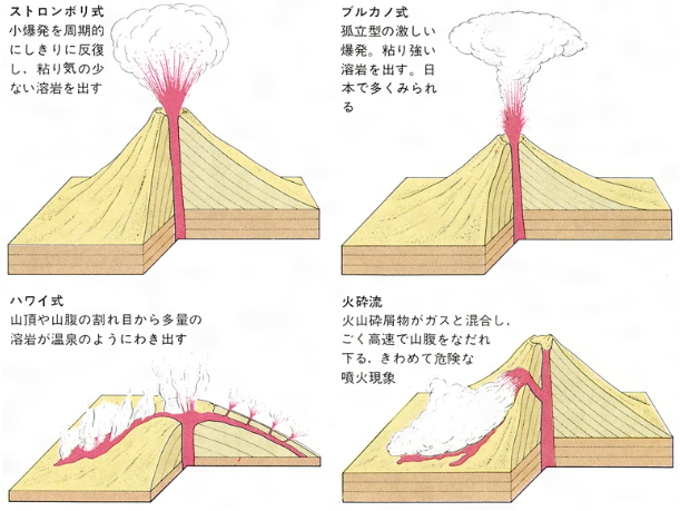
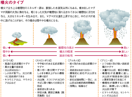
図1.1.5 噴火の様式 |
消防防災博物館(HP/2014/10)による『1 火山の分布と特性』から |
(『最新図表地学』 浜島書店、 2002) 張(HP/2014/10)による『地球科学』の『第7回 火山と噴火』から |
Wikipedia(HP/2014/10)による『Template:Types of volcanic eruptions』から |
Clickable imagemap of notable volcanic eruptions. The apparent volume of each bubble is linearly proportional to the volume of tephra ejected, colour-coded by time of eruption as in the legend. Pink lines denote convergent boundaries, blue lines denote divergent boundaries and yellow spots denote hotspots. Wikipedia(HP/2014/3)による『Volcanic Explosivity Index』から |
噴出したテフラ量の比較〔VEI(火山爆発指数)〕 一番下の円は1815年のタンボラ山(インドネシア:過去2世紀に世界で記録されたもののうち最大規模)噴火。イエローストーンの噴火史の中では比較的小さいとされる64万年前の噴火でもこれよりはるかに大きい。 ウィキペディア(HP/2014/3)による『イエローストーン国立公園』から |
|
|
|
|
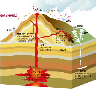
JST(国立研究開発法人科学技術振興機構)によるScience Windowの2009年夏号(8-9月)の『[特集:Let’s go 火山!]火山と噴火の仕組み』(2009/8-9)から |
カルデラ(コールドロン) |
Linearity between caldera area and erupted volume: does it help classification? Giordano(2014)による『Caldera-Forming eruptions』から |
|
Calderas and Cauldrons
|
Morton(2010)による『Calderas』から |
図1.最近 12.5 万年間に日本列島で発生した巨大噴火 図には噴出量 10-100 km3 の噴火が示されている (町田・新井,2003). 伊藤(2007)?による『日本列島における巨大カルデラ噴火』から |
図5.荒島岳コールドロンと西南日本の他の第三紀コールドロンとの大きさと岩石分布の比較.斜線:周囲の基盤岩,細かい網:火山岩,粗い網:深成岩,細かい横線:環状岩脈,短い太線:周囲の岩脈.太線は長さ2km. 石渡(2004)による『福井県大野市の荒島岳コールドロン』から |
火山灰(テフラ) |
※火山砕屑物の総称をテフラ(tephra)と呼ぶが、広域に分布するものは火山灰(volcanic ash)である。日本の場合、偏西風(westerly)の影響で、火山から北東方向へ拡がって分布する。
図9 姶良カルデラ形成時の降下火砕物噴火実績 (姶良Tn火山灰、25,000年前、1.1×10¹¹m3)(出典 「火山灰アトラス」) |
|
図11 噴火規模別・堆積厚さ別の降下火砕物到達距離 (図中の1.0E+09は1.0×10⁹を意味する) |
図13 降下火砕物到達範囲の考え方の模式図 |
国土交通省(HP/2011/11)による『火山災害に係る検討について』から |
赤はマスターテフラ: 鬼界アカホヤ 姶良丹沢 大山倉吉 阿蘇4 阿多鳥浜 加久藤 水鉛谷TE5 小林サクラ 貝塩鳥居峠 B/M境界 猪牟田アズキ 猪牟田ピンク 早川(HP/2011/11)による『日本のテフラ時空間分布図』から |