Wilkinson,B.H. and McElroy,B.J.(2007): The impact of humans on continental erosion and sedimentation. GSA Bulletin, 119(1/2), 140-156.

w‘ε—€‚̐ZHμ—p‚Ƒ͐ύμ—p‚Ι‹y‚Ϊ‚·l—ή‚Μ‰e‹Ώx


wAbstract
@Rock uplift and erosional denudation of orogenic belts have long been the most important geologic processes that serve to shape continental surfaces, but the rate of geomorphic change resulting from these natural phenomena has now been outstripped by human activities associated with agriculture, construction, and mining. Although humans are now the most important geomorphic agent on the planet's surface, natural and anthropogenic processes serve to modify quite different parts of Earth's landscape. In order to better understand the impact of humans on continental erosions, we have examined both long-term and short-term data on rates of sediment transfer in response to glacio-fluvial and anthropogenic processes.
@Phanerozoic rates of subaerial denudation inferred from preserved volumes of sedimentary rock require a mean continental erosion rate on the order of 16 m per million years (m/m.y.), resulting in the accumulation of `5 gigatons of sediment per year (Gt/yr). Erosion irregularly increased over the `542 m.y. span of Phanerozoic time to a Pliocene value of 53 m/m.y. (16 Gt/yr). Current estimates of large river sediment loads are similar to this late Neogene value, and require net denudation of ice-free land surfaces at a rate of `62 m/m.y. (`21 Gt/yr). Consideration of the variation in large river sediment loads and the geomorphology of respective river basin catchments suggests that natural erosion is primarily confined to drainage headwaters; `83“ of the global river sediment flux is derived from the highest 10“ of Earth's surface.
@Subaerial erosion as a result of human activity, primarily through agricultural practices, has resulted in a sharp increase in net rates of continental denudation; although less well constrained than estimates based on surviving rock volumes or current river loads, available data suggest that present farmland denudation is proceeding at a rate of `600 m/m.y. (`75 Gt/yr), and is largely confined to the lower elevations of Earth's land surface, primarily along passive continental margins; `83“ of cropland erosion occurs over the lower 65“ of Earth's surface.
@The conspicuous disparity between natural sediment fluxes suggested by data on rock volumes and river loads (`21 Gt/yr) and anthropogenic fluxes inferred from measured and modeled cropland soil losses (75 Gt/yr) is readily resolved by data on thicknesses and ages of alluvial sediment that has been deposited immediately downslope from eroding croplands over the history of human agriculture. Accumulation of postsettlement alluvium on higher-order tributary channels and floodplains (mean rate `12,600 m/m.y.) is the most important geomorphic process in terms of the erosion and deposition of sediment that is currently shaping the landscape of Earth. It far exceeds even the impact of Pleistocene continental glaciers or the current impact of alpine erosion by glacial and/or fluvial processes. Conversely, available data suggest that since 1961, global cropland area has increased by `11“, while the global population has approximately doubled. The net effect of both changes is that per capita cropland area has decreased by `44“ over this same time interval; `1“ per year. This is `25 times the rate of soil area loss anticipated from human denudation of cropland surfaces. In a context of per capita food production, soil loss through cropland erosion is largely insignificant when compared to the impact of population growth.

Keywords: erosion; denudation; humans; soils; rivers; alluviumx

Introduction
@Continental erosion from sedimentary rock volumes
@Continental erosion from river sediment loads
@@Fluvial denudation
@@spatial variation
@@River sediment fluxes
@Continental erosion from soil-loss data
@@Farmland denudation
@@Spatial variation
@@Farmland sediment fluxes
Potential sources of error
@Temporal and spatial scales of erosion
@Sediment storage behind dams
@Effect of river basin size
@Sediment storage as postsettlement alluvium
Discussion
@Sediment budgets and change in rates of soil erosion
@The impact of humans on continental erosion
@The impact of humans on the global soil reservoir
Conclusions
Acknowledgments
References cited

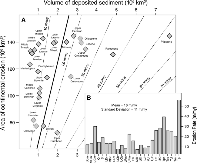
Figure 1. Geologic history of continental denudation from volumes and ages of Phanerozoic sediment. (A) Epoch-interval fluxes of Phanerozoic sediment (horizontal axis; from Ronov, 1983) and areas of continents exposed to subaerial erosion (vertical axis; from Scotese and Golonka, 1992). Dashed diagonals are lines of equal denudation rate; Phanerozoic mean = 16 m/m.y. (heavy solid line). (B) Temporal distribution of denudation rates.

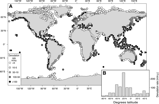
Figure 2. Spatial distribution of continental denudation rates (m/m.y.) needed for total sediment delivery to global oceans. (A) Flux values were derived from suspended sediment fluxes of Ludwig et al. (1996; http://islscp2.sesda.com), assuming a suspended load/bed load ratio of 10 and a particulate load/solution load ratio of 6. These data represent a net weathering flux of `21Gt/yr derived from most ice-free continental land surfaces (`118 ~ 106 km2), and require a mean denudation rate of `62 m/m.y. Note that the highest sediment yields occur across coastal regions at low latitudes and adjacent to regions of rapid uplift (e.g., the Pacific Rim). (B) Distribution of net denudation rates as a function of latitude.

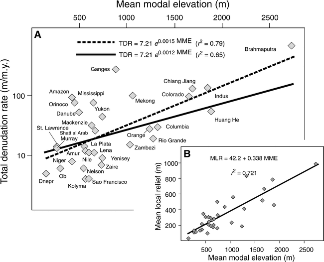
Figure 3. River basin denudation rate and topographic data from Summerfield and Hulton (1994). (A) Relation between mean modal elevation (MME) and total (chemical and mechanical) denudation rate (TDR) for 33 large river basins that drain `39“ (52~106 km2) of Earth's ice-free land surface. Heavy dashed line is the best-fit exponential through the data (denudation decreases `0.15“ with each meter decrease in elevation); heavy solid line is the relation in best agreement with current estimates of river loads, and yields a global sediment flux of `21 Gt/yr. (B) Linear relation between mean modal elevation and mean local relief (MLR).

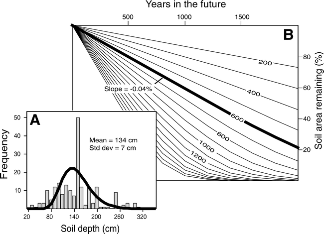
Figure 15. Impact of cropland erosion on areal extent of the global soil reservoir. (A) Frequency distribution of soil profile depths from Webb et al. (1991, 1993). (B) Rates of change in the global soil reservoir anticipated from the population of soil thicknesses in A and different mean rates of cropland erosion. Note that a cropland soil loss of 600 m/m.y. (heavy line) results in a decrease in arable land area of `0.04“ per year.

kWilkinson,B.H. and McElroy,B.J.(2007): The impact of humans on continental erosion and sedimentation. GSA Bulletin, 119(1/2), 140-156.‚©‚ηl


–ί‚ι