Russell,M.J., Weller,D.E., Jordan,T.E.,
Sigwart,K.J. and Sullivan,K.J.(2008): Net anthropogenic phosphorus
inputs: spatial and temporal variability in the Chesapeake Bay
region. Biogeochemistry, 88, 285-304.
üwÉ│¢Īé╠Élłūī╣āŖāōé╠āCāōāvābāgüFā`āFāTāsü[āNśpÆnłµé╔é©é»éķÄ×ŗ¾ŖįĢŽō«üx
üwAbstract
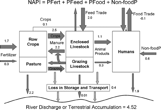
ü@We estimated net anthropogenic phosphorus inputs (NAPI) in the
Chesapeake Bay region. NAPI is an index of phosphorus pollution
potential. NAPI was estimated by quantifying all phosphorus inputs
and outputs for each county. Inputs include fertilizer applications
and non-food phosphorus uses, while trade of food and feed can
be an input or an output. The average of 1987, 1992, 1997, and
2002 NAPI for individual counties ranged from 0.02 to 76.46 kg
P ha-1 year-1. The overall area-weighted
average NAPI for 266 counties in the region was 4.52 kg P ha-1
year-1, indicating a positive net phosphorus input
that can accumulate in the landscape or can pollute the water.
Large positive NAPI values were associated with agricultural and
developed land cover. County area-weighted NAPI increased from
4.43 to 4.94 kg P ha-1 year-1 between 1987
and 1997 but decreased slightly to 4.86 kg P ha-1 year-1
by 2002. Human population density, livestock unit density, and
percent row crop land combined to explain 83üō of the variability
in NAPI among counties. Around 10üō of total NAPI entering the
Chesapeake Bay watershed is discharged into Chesapeake Bay. The
developed land component of NAPI had a strong direct correlation
with measured phosphorus discharges from major rivers draining
to the Bay (R2=0.81), however, the correlation with
the simple percentage of developed land was equally strong. Our
results help identify the sources of P in the landscape and evaluate
the utility of NAPI as a predictor of water quality.
Keywords: Anthropogenic; Budgets; Nutrients; Phosphorus; Watershedüx
Introduction
Methods
ü@Study area
ü@Phosphorus budgets
ü@Phosphorus fertilizer application
ü@Net P import or export in human food and animal feed
ü@Food and feed consumption and non-food P
ü@Crop production
ü@Grazing livestock
ü@Pasture production consumed by grazers
ü@Livestock products for human consumption
ü@Geographic and temporal analysis
ü@Proxy variables for NAPI
ü@Discharge of NAPI
Results
ü@County characteristics
ü@Net anthropogenic phosphorus inputs and geographic differences
ü@Temporal changes
ü@Phosphorus fluxes
ü@Proxy variables
ü@Percentage of NAPI discharged from Chesapeake Bay watershed
Discussion
ü@Decoupled production and consumption
ü@Trade of feed and food
ü@Other possible fates of P
ü@NAPI's relationship to nutrient discharges
ü@Temporal trends
Conclusion
References
āzü[āĆéų