『Abstract
A simple modelling approach was developed to link patterns of
urban land-use with ground water flow and chemistry in three dimensions
and was applied to characterize the origin of recharge in the
aquifer beneath the old industrial city of Nottingham, UK. The
approach involved dividing land uses into types, and times into
periods, and assigning the recharge from each an individual tracer-solute
with a unit concentration. The computer code MT3DMS was used to
track the multiple tracer-solutes in transient, three-dimensional
simulations of the important urban aquifer. A depth-specific hydrochemical
dataset collected in parallel supported the model predictions.
At depth under the industrial area studied, a large component
of ground water originated of older agricultural origin, with
relatively low nitrate concentrations. Shallower ground water
originated mainly from residential and industrial areas, with
higher nitrate concentrations probably arising from leaking sewers
and contaminated land. The results highlighted the spectrum of
ground water from different origins that amalgamate even at short
well screens in a non-pumped borehole and remind us that the non-point-source
pollution of ground water from anthropogenic activities will involve
more years of slow degradation of quality.
Keywords: Urban; Recharge; Ground water; Model; Land use; Nitrogen』
1. Introduction
2. Approach
3. Case study
4. Numerical model
5. Results and discussion
6. Conclusions
Acknowledgments
References
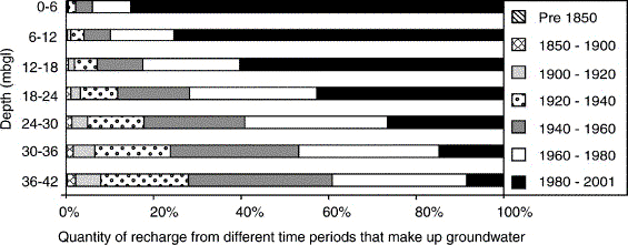
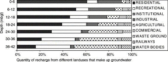
mbgl: meters below ground level Fig. 4. Modelled percentages of recharge that have originated from different land-use types at depth in the multi-level piezometer. Fig. 5. Modelled percentages of recharge that have originated from different time periods at depth in the multi-level piezometer. 〔Trowsdale,S.A. and Lerner,D.N.(2007): A modelling approach to determine the origin of urban ground water. Journal of Contaminant Hydrology, 91, 171-183.から〕 |