Nokleberg,W.J.(ed.): Metallogenesis
and Tectonics of Northeast Asia. Professional Paper 1765,
U.S. Department of the Interior/U.S. Geological Survey, 630p.
üw¢kōīāAāWāAé╠Źzē╗ŹņŚpéŲŹ\æóē^ō«üx
Contents
1. Introduction......................................................................................................................................1-1
2. Methodology of a Combined Regional Metallogenic and Tectonic
Analysis for Northeast Asia...2-1
3. Mineral-Deposit Models for Northeast Asia...3-1
4. Archean through Mesoproterozoic Metallogenesis and Tectonics
of Northeast Asia...4-1
5. Neoproterozoic through Silurian Metallogenesis and Tectonics
of Northeast Asia...5-1
6. Devonian through Early Carboniferous (Mississippian) Metallogenesis
and Tectonics of Northeast Asia...6-1
7. Late Carboniferous through Early Jurassic Metallogenesis
and Tectonics of Northeast Asia...7-1
8. Middle Jurassic through Quaternary Metallogenesis and Tectonics
of Northeast Asia...8-1
9. Tectonic and Metallogenic Model for Northeast Asia...9-1
Appendix A. Description of the Northeast Asia Project and Associated
Product..A-1
Appendix B. Description of Map Units for Northeast Asia Summary
Geodynamics Map...B-1
Appendix C. Summary of Major Metallogenic Belts in Northeast
Asia (the Russian Far East, Yakutia, Siberia, Transbaikalia, Northern
China, Mongolia, South Korea, and Japan) ...C-1
Introduction
Executive Summary
The major purpose of this volume is to provide a comprehensive
synthesis of the regional geology, tectonics, and metallogenesis
of Northeast Asia for readers who are unfamiliar with the region
and for researchers who desire detailed information on the region.
The major parts of the volume are (1) an introductory chapter;
(2) a chapter on methodology of regional metallogenic and tectonic
analysis; (3) a chapter on mineral deposit models for the region;
(4) five chapters that describe the regional metallogenesis and
tectonics of the region from the Archean through the Present for
successive time stages; (5) a chapter on a metallogenic and tectonic
model for the region; and (6) three appendixes, including on a
description of the project and products, a description of map
units for the Northeast Asia geodynamics map, and a summary table
of metallogenic belts for the region.
An important goal of the volume is to demonstrate how a high-quality
metallogenic and tectonic analysis, including construction of
an associated metallogenic-tectonic model, greatly benefits other
mineral resource studies by (1) synthesizing of mineral-deposit
models, (2) improving prediction of undiscovered mineral deposits
as part of quantitative mineral-resource-assessment studies, (3)
assisting land-use and mineral-exploration planning, (4) improving
knowledge of regional geology; (5) improving interpretations of
the origins of host rocks, mineral deposits, and metallogenic
belts, and (6) suggesting new research.
Research on the metallogenesis and tectonics of such major regions
as Northeast Asia requires a complex methodology including (1)
definitions of key terms, (2) compilation of a regional geologic
base map that can be interpreted according to modern tectonic
concepts and definitions, (3)
compilation of a mineral-deposit database that enables a determination
of mineral-deposit models and clarification of the relations of
deposits to host rocks and tectonic origins, (4) synthesis of
a series of mineral-deposit models that characterize the known
mineral deposits and inferred undiscovered deposits in the region,
(5) compilation of a series of metallogenic-belt belts constructed
on the regional geologic base map, and (6) construction of a unified
metallogenic and tectonic model.
The Northeast Asia study area consists of eastern Russia (most
of eastern Siberia and the Russian Far East), Mongolia, northern
China, South Korea, Japan, and adjacent offshore areas. Major
cooperative agencies are the Russian Academy of Sciences; the
Academy of Sciences of the Sakha Republic (Yakutia); VNIIOkeangeologia
and Ministry of Natural Resources of the Russian Federation; the
Mongolian Academy of Sciences; the Mongolian University of Science
and Technology; the Mongolian National University; Jilin University,
Changchun, Peopleüfs Republic of China; the China Geological Survey;
the Korea Institute of Geosciences and Mineral Resources; the
Geological Survey of Japan/AIST; the University of Texas, Arlington;
and the U.S. Geological Survey (USGS).
This study builds on and extends the data and interpretations
from a previous project on the Major Mineral Deposits, Metallogenesis,
and Tectonics of the Russian Far East, Alaska, and the Canadian
Cordillera conducted by the USGS, Geological and Geophysical Surveys,
and the Geological Survey of Canada. The major products of the
Northeast Asia project are described in appendix A.
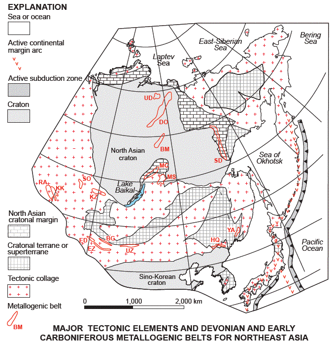
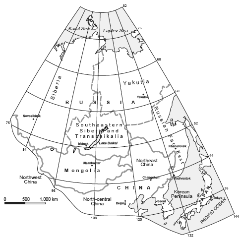
Figure 1. Regional summary regional geographic map of Northeast
Asia, showing locations of major regions, countries, andü@capitals.
International boundaries of onshore areas are approximate and
do not imply ü@endorsement by participating countries.
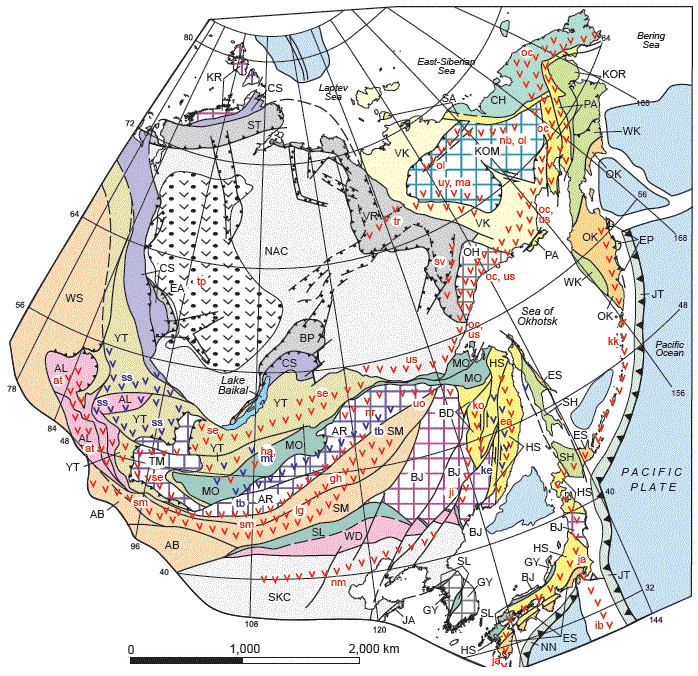
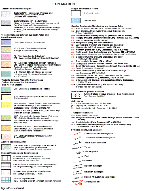
Figure 2. Northeast Asia summary geodynamics map (scale,
approx 1:34,000,000) showing locations major geologic and
tectonic units including cratons, cratonal margins; cratonal
terranes and superterranes; tectonic collages; overlap and transform
continentalmargin-arcs; island arcs, and sea and ocean units.
From (1) a generalized geodynamics map of Northeast Asia (scale,
1:10,000,000)ü@by Parfenov and others (2004), (2) a more detailed
geodynamics map Northeast Asia (scale 1:5,000,000 and (3) tectono-stratigraphic
terrane maps of the western part of a Circum-North Pacific (scale,
1: 10,000,000) by Nokleberg and others (1997). Tectonic interpretations
are based on the major interpretative reports of collaborative
international studies of Northeast Asia (Nokleberg and others,
2004) and the Circum-North Pacific (Nokleberg and others, 2000,
2004), with descriptions of geologic units adapted from reports
by Nokleberg and others (2000, 2004) and Parfenov and others
(2004). See appendix B for descriptions of map units.
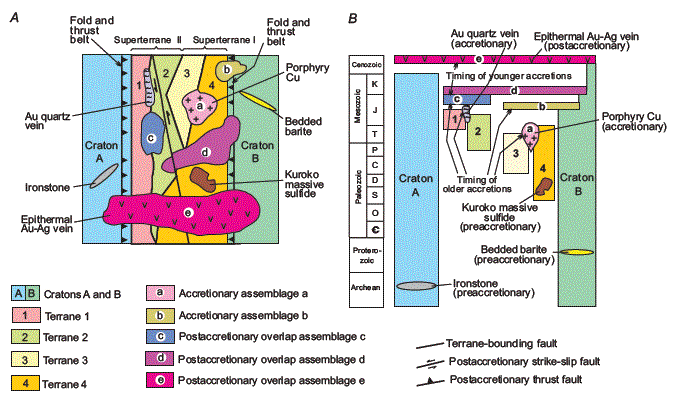
Figure 1. Schematic diagram illustrating methodology of combined
regional and metallogenic and tectonic analysis of cratons, terranes,
accretionary assemblages, post-accretopmaru overlap assemblages,
and contained metallogenic belts. A. Map view of orogenic
belt. B. Stratigraphic columns for orogenic belt.
Adapted from Parfenov and others (1998)
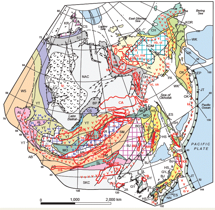
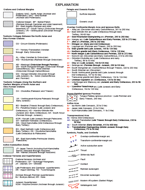
Figure 3. Summary geodynamic map of Northeast Asia showing
outlines of major metallogenic belts for the Middle Jurassic
through Early Cretaceous. Adapted from Obolenskiy and others
(2003, 2004) and Parfenov and others (2003, 2004). Regional geology
for area east of 144oE longitude (eastern boundary of Northeast
Asia project area) as described and interpreted by Nokleberg
and others (2000, 2005).
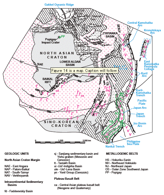
Figure 14. Miocene (10 Ma) time stage of tectonic and metallogenic
model. See text for explanation of tectonic events and origins
of major metallogenic belts and figure 3 for explanation of symbols
and patterns.
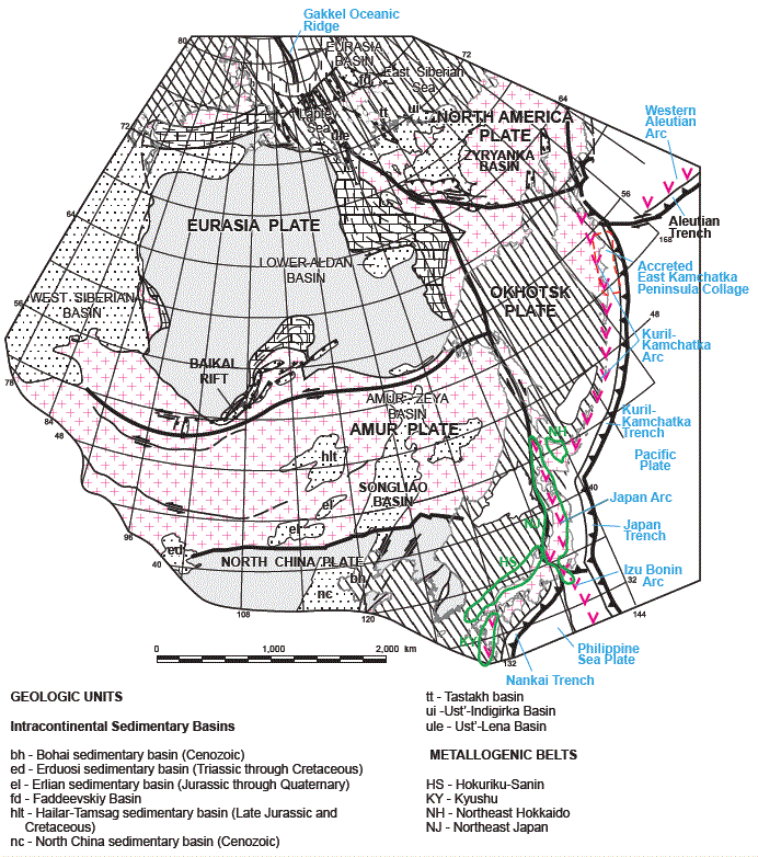
Figure 15. Present (0 Ma) time stage of tectonic and metallogenic
model. See text for explanation of tectonic events and origins
of major metallogenic belts and figure 3 for explanation of symbols
and patterns.
USGSé╔éµéķüwMetallogenesis
and Tectonics of Northeast Asiaüxé®éń |
āzü[āĆéų