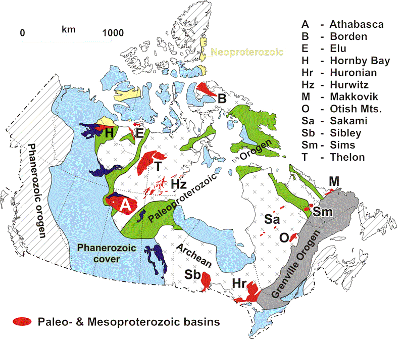
Figure 1:
Paleo- to Mesoproterozoic basins within the Canadian Shield that
contain unconformity-associated uranium deposits (e.g. Athabasca
and Thelon) or are considered to have potential for them.
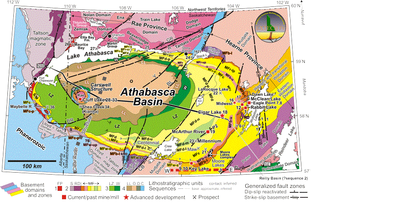
Figure 4a:
Geological setting and unconformity-associated uranium occurrences
(numbered as in the Appendix) of the Athabasca Basin region in
northern Saskatchewan and Alberta, where Rae and Hearne are termed
‘Province’ rather than Subprovince (see Fig. 2). Symbols and
fonts are slightly larger for more significant occurrences. Basement
geology is after Portella and Annesley (2000a), Thomas et al.
(2002) Card et al. (2003, 2007a, b), and Card (2006). Athabasca
Basin geology and stratigraphic units (Table 3) are from Ramaekers
et al. (2007). C = Carswell, D = Douglas, FP = Fair Point, LL
= Locker Lake, LZ = Lazenby Lake, MF = Manitou Falls (members:
b = Bird (l = lower, u = upper) c = Collins, d = Dunlop, r =
Raibl (up = upper pebbly), w = Warnes (up = upper pebbly)), O
= Otherside, RD = Read, S = Smart, W = Wolverine Point, d = diabase.
Members of LZ, LL, and O are indicated by lines and labels but
only one shade is used per formation. The western Wollaston Domain
and the Wollaston ? Mudjatik transition of Portella and Annesley
(2000a,b) are combined here as “Wollaston-Mudjatik transition
zone”. CIS = Carswell Structure. Generalized fault zones after
Ramaekers (2004) include multiple ductile movements before deposition
of Athabasca Group and brittle transcurrent and dip-slip movements
during and after deposition; they are named as: A = Allan, BB
= Black Bay, BL = Black Lake, BR = Beatty River, BU = Bustard,
CB = Cable Bay, CH = Charlot, CHB = Charbonneau, CL = Charles
Lake, CT = Clut, D = Dufferin, ER = East Rim, F = Fidler, FN
= Fowler?Net Lake, GR = Grease River, H = Harrison, HT = Hudsonian
thrusts (general trajectory), LL = Leland Lakes, MAY = Maybelle,
NF = Needle Falls, PL = Parker Lake, P2 = P2 fault at McArthur
River, R = Richardson, RI = Riou, RL = Reilly Lake, RO = Robillard,
RON = Robillard north, ROS = Robillard south, SL = St. Louis,
T = Tabbernor, VR = Virgin River array (Dufferin is one named
fault of many in VR), Y = Yaworski, YH = Yatsore-Hill Island.
Arrays of faults with similar orientation and offset are indicated
by colour groups.
A. Simplified bedrock geology. Cross-sections of Figue
5A and B are located along dotted lines labelled NW - SE (along
the basin axis) and E - W (south of Key Lake).
B. Outlines of stratigraphic units of the Athabasca Group
(black), basement domains (white outlines) and major reactivated
fault systems (heavy coloured lines) on total magnetic field
(Geological Survey of Canada, 1987; Pilkington, 1989). Faults
are after Portella and Annesley (2000a), Ramaekers (2004), Card
et al. (2007a), and Thomas and McHardy (2007). Many late faults
have limited offsets that cannot be shown at this scale (see
Card, 2007).
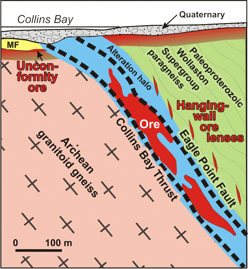
Figure 9c:
Examples of three end-point shapes and positions of unconformity-associated
uranium deposits, after Thomas et al. (2000) and Andrade (2002)
located in the southeastern part of Athabasca Basin (Fig. 4).
(A) Cigar Lake (underground, production expected to start
about August 2007) is dominantly unconformity ore with minor
basement-hosted lenses and perched ore in the overlying Manitou
Falls Formation. B) Deilmann (open pit, mined out) at
Key Lake included both basement-hosted and unconformity ore.
C) Eagle Point is mostly basement hosted (originally mined
by open pit and underground; hanging wall lenses still being
developed and mined underground (LeMaitre and Belyk, oral presentation
2005). Vertical scale = horizontal scale in (B) and (C).
カナダ地質調査所(Geological Survey of Canada)による『Mineral Deposits of Canada Maps of deposits and resources(world)』から