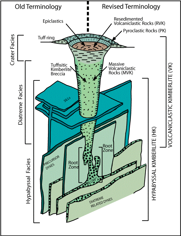
Figure 10:
The classic South African model of a kimberlite pipe with old
nomenclature (left side of figure) and a simpler, revised two-fold
nomenclature system (right side of figure) to describe rocks
from kimberlite magmatic systems (Mitchell, 1995; Kjarsgaard,
2003; Sparks et al., 2006). PK = pyroclastic kimberlite; RVK
= resedimented volcaniclastic kimberlite; MVK = massive volcaniclastic
kimberlite; HK = hypabyssal kimberlite. Figure modified after
Kjarsgaard, 2003).
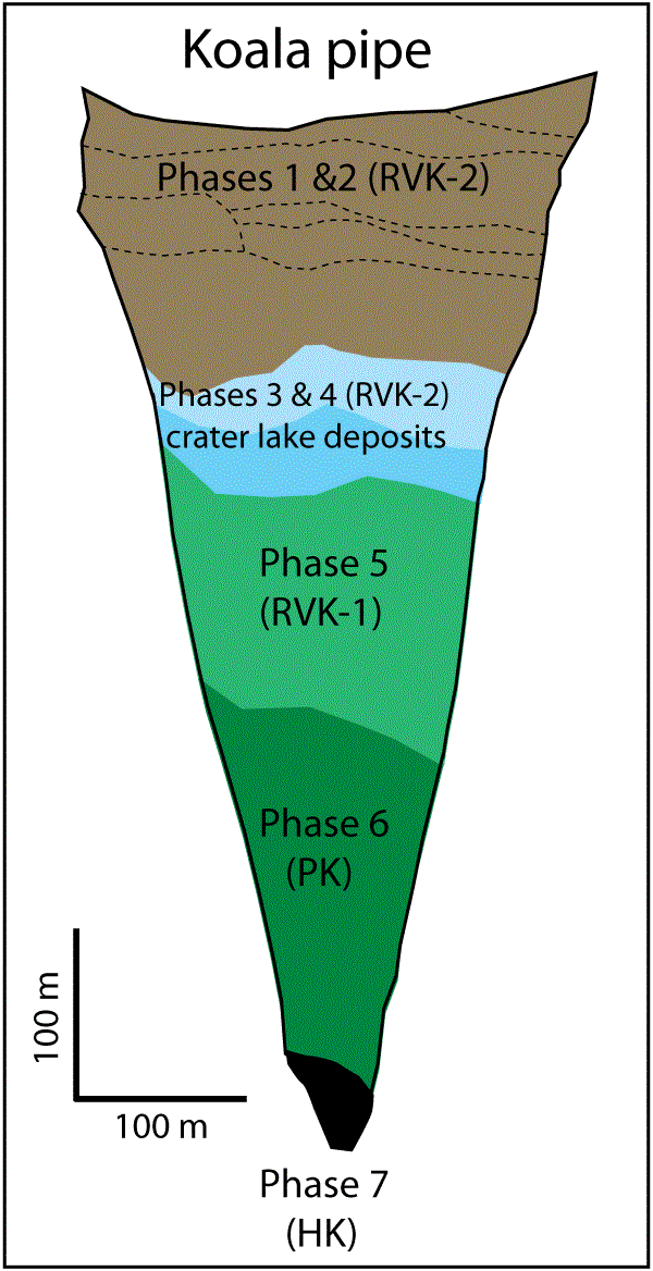
Figure 19:
Geological cross section of the steep sided, inverted cone shaped
Koala kimberlite body, Ekati Mine, Lac de Gras field. Phase 7
is hypabyssal kimberlite (HK) and Phase 6 is pyroclastic kimberlite
(PK) (Crawford et al., 2006). Phase 5 is interpreted here as
syn-eruption resedimented volcaniclastic kimberlite (RVK-1),
phase 4 and 3 are interpreted here as crater lake sediments,
and phases 2 and 1 are interpreted as post-eruption resedimented
volcaniclastic kimberlite (RVK-2). Internal phases within phase
1 & 2 demarcated by dashed lines. Modified after Nowicki
et al. (2003) and Crawford et al., (2006).
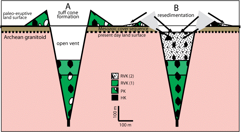
Figure 20:
A) Scaled model for the reconstruction of a kimberlite tephra
cone at the Koala pipe, NWT. The tephra cone is 600 m in diameter
and 108 m high with a crater rim diameter of 300 m an angle of
repose of ~36°, and an internal crater wall angle of ~78°. The
tephra cone sits on a 32 m thick Mesozoic cover sequence, on
top of Archean granitoids. B) Resedimentation of kimberlite (from
the tephra cone) and cover sequence sediments by grain flow and
slumping processes, into the open excavated pipe. The model assumes
it is not feasible for the entire tephra cone to be resedimented
into the open pipe, i.e., tephra will also be displaced away
from the open pipe. 1:1 scale, no vertical exaggeration. Adapted
and modified after Kjarsgaard (2003, 2007).
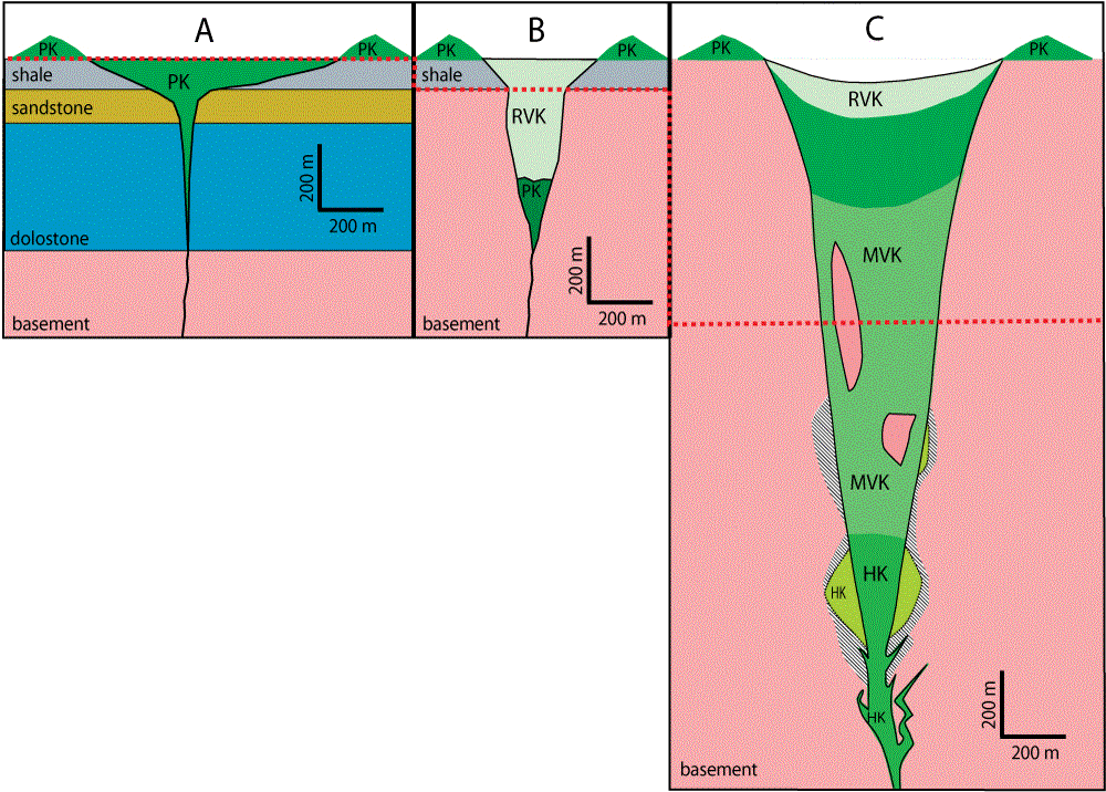
Figure 21:
Highly oversimplified (non-relevant) models of kimberlite pipes
(adapted from Scott-Smith, 2006; [Fig. 21 A, B] and Field and
Scott-Smith, 1999) Fig. 21 C]) Note the original figures are
to the correct scale in this diagram. Compare A) with Fig. 17
and note there is no relationship. See the text and also Kjarsgaard
et al. (2007) for further discussion of the geometry and architecture
of Fort a la Corne kimberlites. Contrast the additional complexity
of a Lac de Gras kimberlite (Fig. 19) with that shown in Figure
21 B. The 'classic South African model' kimberlite pipe shown
in Figure 21 C exhibits a regular change in geologic units from
PK and RVK (top) to MVK (middle) to HK (bottom) which is a severe
oversimplification of the morphology of this style of kimberlite
pipe (compare with Figs. 18 a, b, c).
カナダ地質調査所(Geological Survey of Canada)による『Mineral Deposits of Canada Maps of deposits and resources(world)』から